Try it, you won’t go back!
Everything you need to know about our Cloudstation Viewer
Yes. CloudStation Viewer is free to download and use. There is no paid license required to view LiDAR datasets.
No. The interface is designed for non-specialists. If you can navigate a 3D map, you can explore a point cloud.
CloudStation Viewer supports LAS, LAZ, and TXT files, covering the most common LiDAR formats.
No. It works with data from any LiDAR sensor, including UAV, airborne, terrestrial, mobile systems, and relevant exports from smartphones.
Windows 10 & Windows 11
Yes. CloudStation Viewer is ideal for universities, training centers, and research labs that want to introduce LiDAR
WHY CLOUDSTATION VIEWER ?
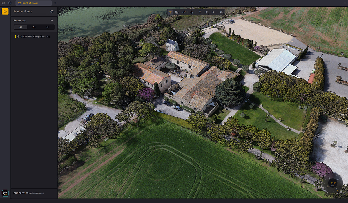
Powerful LiDAR data. Simplified.

LiDAR is now everywhere. On UAVs, cars, smartphones.
Surveys can generate dozen to billions of points, capturing terrain, infrastructure, forests, rivers, and coastlines in incredible detail. You can now vizualize it easily

CloudStation Viewer changes the way you read LiDAR data.
It’s a free, universal LiDAR viewer that makes point-cloud exploration accessible to everyone from engineers and surveyors to institutions, educators, and new corners eager to learn about LiDAR.
FOR WHO ?
From neophytes to experts
CloudStation Viewer is built for anyone who needs to see and understand LiDAR data.

Tech enthusiasts
& Open-Data
Explore national LiDAR datasets (IGN LiDAR HD, USGS 3DEP, Copernicus DEM, etc.) and better understand your environment.

Surveyors
& Engineers
Validate field surveys, review deliverables, and share results with clients and project owners.

Civil Engineering
& Construction
Visualize construction sites, corridors, and infrastructure in 3D. Communicate project stages more clearly.

Forestry
& Environment
Explore canopy structure, riverbanks, erosion areas, and natural habitats using dense 3D data.

Disaster Risk
& Public Authorities
Review flood-risk zones, coastline retreat, or landslides with local decision-makers and stakeholders.

Universities
& Research Labs
Integrate real point clouds into courses, student projects, and research work without extra license costs.
WHY NOW ?
LiDAR is everywhere. It’s time everyone can read it.
LiDAR is no longer confined to a few specialists.
- Sensors are smaller and more affordable
- UAVs are widely used in mapping and inspection
- Smartphones increasingly integrate LiDAR modules
- Governments release massive open LiDAR datasets (IGN LiDAR HD, USGS 3DEP, Copernicus DEM, and others)
This creates an unprecedented opportunity and a challenge: how do we make these billions of points understandable to everyone?
CloudStation Viewer is YellowScan’s answer: a tool that turns complex point clouds into a shared language between engineers, decision-makers, educators, and citizens.


KEY FEATURES
Technical Specifications
- Distance & height measurements
- Simple filtering
- Easy 2-click slicing
CloudStation Viewer
Free LiDAR Viewer for Everyone
Download CloudStation Viewer

Runs on standard Windows PC
Open any point cloud in seconds
- Supports LAS, LAZ, TXT
- Open georeferenced data
- Easy installation

Visualize and explore in 3D
- Navigate smoothly in 3D
- Display any size of point-clouds
- Measure distance, height, profiles)

Keep full control of your LiDAR data
- Deliverables viewable for free
- Your point-clouds stay local, secure, and fully in your hands
- Ideal companion to YellowScan survey deliverables and open-data workflows
