Landslide monitoring using UAS LiDAR

Challenge
The University of Vermont (UVM) in the USA became involved in this project through its connections with the Vermont Geological Survey (VGS) and the Vermont Agency of Transportation (VTrans). UVM is one of the few organizations in the state with access to UAS LiDAR technology, making it a priority contact for capturing accurate elevation data and models for landslides, especially when rapid data collection was required.
UVM is also a core university of ASSURE, the FAA’s center of research excellence. Through these landslide missions, UVM documented important information on using UAS for disaster response, contributing to further research in this field.
The goal was to capture accurate elevation data of the landslides for monitoring purposes. For larger landslides, such as those at Smuggler’s Notch and Cottonbrook, the focus was on understanding land movement over time and identifying any signs of loose debris for volume estimations or potential future large-scale landslides.
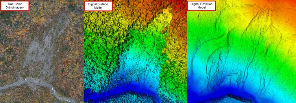
These projects required accurate UAS LiDAR capable of penetrating dense tree canopies and debris to capture ground points. The data needed to be accurate for creating volume estimations of debris, which could then be compared to previous data captures and used to monitor ground movement, such as new cracks or slides beneath dense tree canopies. Additionally, UVM needed a sensor with a large field of view (FOV) to reach difficult locations, such as the extreme vertical cliffs of Smuggler’s Notch.
Solution
UVM chose the first-generation YellowScan Surveyor Ultra for its 360-degree field of view capabilities, which was particularly useful for capturing the vertical faces at Smuggler’s Notch. Additionally, its 3-echo capability was invaluable for penetrating dense tree canopies during leaf-on conditions at Cottonbrook, allowing them to detect individual cracks and slides that were previously unnoticed.
The Surveyor Ultra was extremely helpful in their research on landslides and rockfalls with vertical faces, especially in areas where much of the ground was covered by dense tree canopies. Paired with the DJI Matrice 300 RTK, they could easily navigate the challenging terrains of these landslides through meticulous planning. This enabled them to capture data that is typically difficult to obtain.
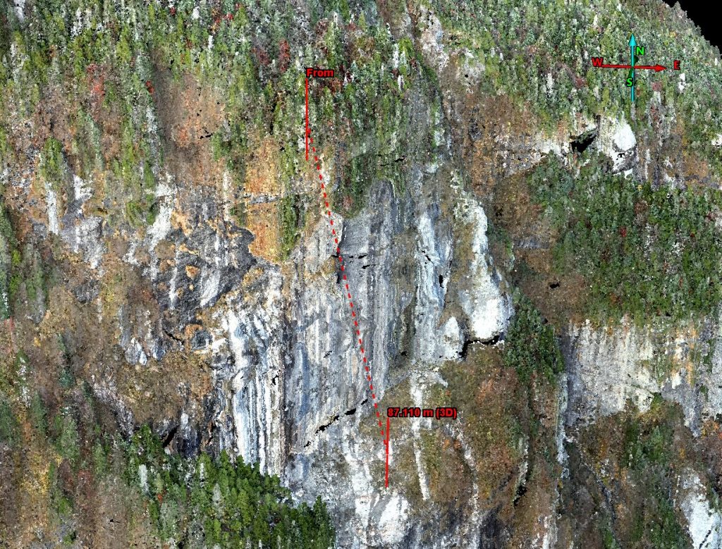
Smuggler’s Notch vertical face
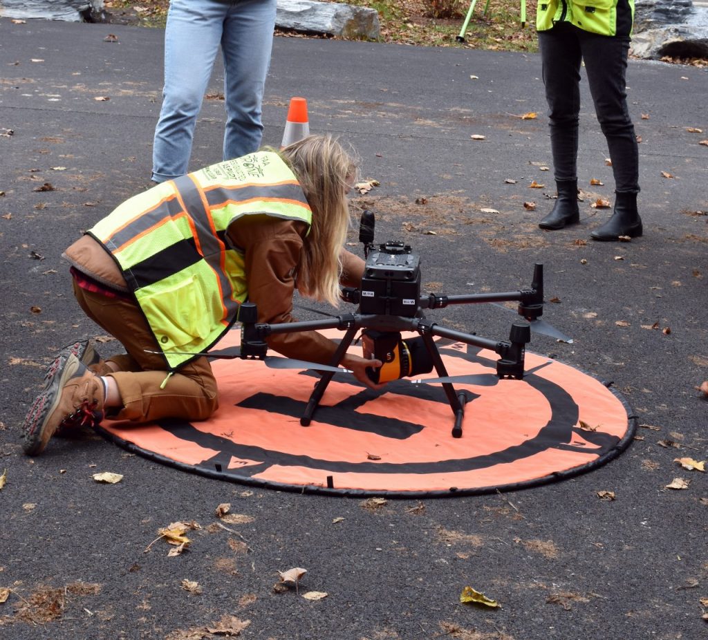
YellowScan Surveyor Ultra on a DJI M300
Mission parameters
- Survey size:
Smugglers Notch – 25.8 hectares
Cottonbrook – 42.7 hectares - Duration:
Smuggler’s Notch – 1 week for planning, acquisition was 30 minutes, and about 1-2 weeks for processing (manual classification of points for QA/QC extend this duration)
Cottonbrook – 1 week for planning, acquisition was 35 minutes, 1 week for processing - Number of flights:
Smuggler’s notch: 2 LiDAR flights, 1 photogrammetry
Cottonbrook: 2 LiDAR flights , 1 photogrammetry - Flight speed and altitude: 5m/s flight speed for all, 70m flight height
- Equipment used: First-generation YellowScan Surveyor Ultra (main sensor) + Mapper (back-up sensor), DJI M300 RTK + DJI Zenmuse P1 (for photogrammetry), Cloudstation with the strip adjustment module, trajectory correction was using a CORS station that is managed by the Vermont Agency of Transportation (VTrans)
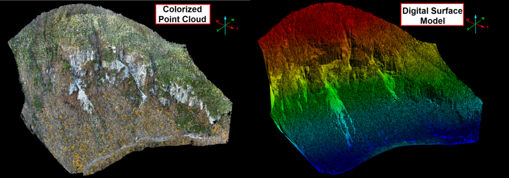
Smuggler’s Notch point cloud and Digital Surface Model
Results
- Point Cloud Density: 1000+ ppm² (Cottonbrook).
When comparing past data to state LiDAR (digital elevation and surface models), the results showed differences of 3-5 cm, which gave them confidence in the data acquisition. Even under dense tree canopies, the ground points produced digital elevation models that state geologists appreciated. For example, at Cottonbrook, UVM extracted cracks and small valleys beneath the trees, as well as slips in the landslides. At Smuggler’s Notch, they captured detailed cross-sections of the vertical face for future comparisons.
The data we collected was valuable for the state geologists’ annual reports on the Smuggler’s Notch and Cottonbrook landslides, including changes in vertical faces and fallen debris. High-resolution data captured beneath the tree canopies at Cottonbrook revealed previously unseen cracks. Also, during flood-induced landslides, the data provided critical information for the state geologists to address evacuation or safety concerns for town planners and first responders across Vermont, enhancing confidence in decision-making.
The easy setup and post-processing in the YellowScan CloudStation enabled fast and quality data models for reports and further analysis with the Vermont Geological Survey. Streamlining data capture and processing is crucial for these annual projects, ensuring continued success.
*Note that this article focuses on our discontinued first-generation Surveyor Ultra. To learn about our latest generation, click here.
Cottonbrook landslide underneath tree canopies
Using a YellowScan LiDAR system with a drone provided significant benefits, allowing us to quickly capture high-quality data in remote locations inaccessible by foot. With this technology, we efficiently surveyed large areas for elevation and surface data within minutes and processed it within hours. Additionally, during summer landslides, prompt assistance from the YellowScan support team helped address noise issues and ensure sensor health checks.