Navigator.UAV Bathymetric LiDAR for Shallow Water Survey
Ready to get started?
Let’s talk! Our team of experts can help you clarify your needs and propose the most suitable solutions for you to successfully complete your mission.
Frequently asked questions
Based on visible green light emission, bathymetric LiDAR enables the measurement of topography under water. This allows for crucial mapping of coastlines with continuity under water.
Water “absorbs” certain light wavelengths much more than others. Depending on the water, absorption varies as well, however a trend is usually blueish-green penetrates the most.
The YellowScan Navigator is a Class 3B laser product. Appropriate eyewear protection is mandatory to avoid eye injuries from the laser beam. Do not use sunglasses for laser protection and quickly proceed to get the drone at 30m AGL to ensure Nominal Ocular Hazard Distance (NOHD). Always make sure nobody is within 25m of the drone or LiDAR while active.
The applications are many and varied. The YellowScan Navigator system can be used for river and lake analysis, coastal oceanography, safety of hydraulic structures, submarine archaeology, surface water hydrology, dredging and marine works.
The Secchi Disc was created by Angelo Secchi and used to measure water transparency / turbidity in bodies of water. The marine Secchi disc is a plain white, ø30 cm disc mounted on a pole. The freshwater Secchi disc is ø20 cm and features black quadrants.
A Secchi is the depth at which it is not possible to distinguish the disc in water. This depth varies according to the water’s turbidity and subjectively distinguishing the disc by the observer.
For example, if 1 Secchi is 2.2m under water, a 2 Secchi system will be able to measure up to 4.4m underwater approximately.
No, you can’t mount the YellowScan Navigator system on the DJI M300/350 drone. The weight of the system (incl. battery) exceeds the manufacturer’s recommended maximum payload capacity (2.7 kg).

LASER SCANNER
A YellowScan development
This solution features a laser scanner developed in-house by our R&D team over the last few years with tests that kicked off in 2023, refining the system for optimal performance. This evolution highlights our commitment to innovation and quality, particularly in the development of advanced laser scanners.
Key figures
- View detailed characteristics
- Precision3 cm (1.2")
- Accuracy3 cm (1.2")
- Typ. flight speed5 m/s
- Max. AGL altitude100 m
- Point density20 pts/sqm @ 80 m AGL 5 m/s
- Laser rangeUp to 120 m
- Laser scannerYellowScan development
- GNSS-Inertial solutionSBG Quanta Micro
- Scanner field-of-view40°
- Echoes per shotUp to 10
- Shots per secondUp to 20 000
- Scanning frequencyUp to 50 Hz
- Weight3.7 kg (8.2 lbs) battery excl.
- SizeL 350 x W 160 x H 190 mm
- Autonomy45 min. typ.
- Power consumption120 W
- Nominal ocular hazard distance25 m
- Laser classClass 3B
- Max. water depth2 Secchi
- Integrated cameraBuilt-in global shutter
A variety of mission profiles


UAV INTEGRATION
Multi-platform adaptability
This system can be used on multirotor or helicopter UAVs. When it comes to drones, the “quick release” GREMSY attachment allows for easy mounting on a wide range of drones.
View the integrations list


Accessories
So, what’s included ?

1 Rugged Pelicase
3.9 kg

1 Navigator
3.7 kg

1 Gremsy adapter
Quick release

2 batteries + 1 Charger
RRC 2054-2 14.4V

1 GNSS Antenna AV18
for YellowScan systems

1 Laser safety goggle
High optical density

2 USB keys
YellowScan 1To x2

CloudStation Essential
1 licence

SBG Qinertia UAV
1 licence

Technical support
1-year unlimite

Warranty
1 Year

1 Remote healthcheck

In-person or online training

Boresight calibration certificate
Optional add-ons

1 Mounting Bracket
Universal

CloudStation Pro
1 licence

Extensions
Warranty and technical support extensions
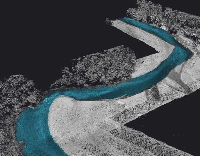
Automated water surface detection
Our software’s capability for automated water surface detection efficiently identifies water boundaries, streamlining data analysis for precise bathymetric mapping.


Underwater point correction
The underwater point correction in the CloudStation refines submerged data points, taking into account water refraction and ensuring reliable bathymetric mapping with uncompromised accuracy.

Embedded camera
The Navigator features an embedded camera (global shutter) that can be used for colorization purposes.


Testimonials
A word from our customer

General Manager
Scandinavian Drone
Norway
Advanced calibration
All our systems are calibrated before shipment and come with a calibration certificate. Be ready to fly your system as soon as you receive it!

On-site training
YellowScan delivers complete training to new customers. The training is provided over 2 days and can take place at your premises or online.

Technical support
Our 1 year unlimited technical support from our experts enables you to confidently undertake your projects, whether you are new or experienced in the field.

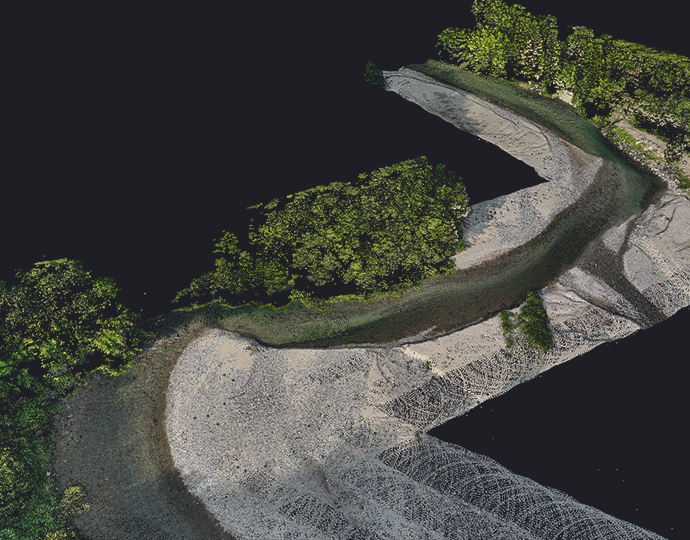
Simultaneous land & water survey
The YellowScan Bathymetric system is designed for conducting bathymetric measurements in shallow waters and is rapidly deployable on a UAV. This full waveform LiDAR system ensures continuity between underwater points and the surrounding terrain.

Diverse water environments
Intended for aerial use on drones, the system covers various water areas such as shorelines, rivers, lakes, estuaries, ponds and gravel pits. Navigator is user-friendly and adaptable for a wide range of applications, from hydrographic surveys to underwater resource management.

40° FOV for high precision
Our bathymetric system, with a 40-degree field of view, prioritizes precision over a broader angle. This decision is based on the fact that 40° is the maximum angle for a green laser to perform effectively underwater. Beyond this angle, the laser’s penetration depth in water is significantly affected, limiting the system’s overall performance.

High autonomy for maximized efficiency
Optimize your bathymetric survey operations with our LiDAR system, delivering a 45-minute autonomy on a single battery charge for extended underwater data collection in various marine settings.
