Fly&Drive.
Fly when you can. Drive when you must.
Ready to get started?
Let’s talk! Our team of experts can help you clarify your needs and propose the most suitable solutions for you to successfully complete your mission.
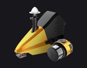
A multi-platform LiDAR for geospatial survey scanning from air to ground.
The Fly & Drive is a versatile, land vehicle or UAV-mounted, mobile mapping system that combines high-resolution laser scanning and precise positioning to collect geo-referenced pointclouds.
Key figures
- View detailed characteristics
- Precision2 cm
- Accuracy3 cm
- Typ. flight speed10 m/s
- Max. AGL altitude140 m
- Point densitySurveyor Ultra: 60 pts/sqm @ 100m AGL 10 m/s
- Laser rangeSurveyor Ultra: Up to 300m
- Laser scannerSurveyor Ultra: Hesai XT32M2X
- GNSS-Inertial solutionSurveyor Ultra: SBG Quanta Micro
- Scanner field-of-viewSurveyor Ultra: 360° x 40.3°
- Echoes per shotSurveyor Ultra: Up to 3
- Shots per secondSurveyor Ultra: Up to 640 000
- Scanning frequencySurveyor Ultra: Up to 20 Hz
- WeightSurveyor Ultra: 0.98 kg (2.2 lbs) batt. excl.
- SizeSurveyor Ultra: L 153 x W 113 x H 117 mm
- AutonomySurveyor Ultra: 1.2 hour typ.
- Power consumptionSurveyor Ultra: 20 W
- Typ. driving speedUp to 90km/h
A variety of mission profiles


Multi-scope mobile (ground) and UAV (airborne) mapping systems
The system can be deployed rapidly on road vehicles as well as on all types of UAV (multicopter, traditional, and VTOL fixed-wing).
This flexibility allows you to expand your range of applications (e.g. vertical elements or no-fly zones), which will increase your return on investment and thereby decrease the system’s payback period.
View the integrations list


Setup
Mobile mapping & aerial survey using the same LiDAR
Here’s what’s included

1 Hardshell backpack
3.2 kg

1 Pod
For land vehicle

1 Surveyor Ultra
983 g

1 Mounting Bracket
for DJI M300/350

1 GNSS Antenna AV18
for YellowScan systems

CloudStation Essential
1 licence
Optional add-ons

1 odometer

2 LiveStation modems
2km range

1 external power supply
Compatible with cigarette lighter

1 roof-bar adaptors
for Fly & Drive POD
CloudStation Pro
1 licence

YellowScan LiveStation
1 licence
Fly&Drive knowledge base
Discover our solutions by reading about our users’ experience in the field.

Hero Image for How Weather Really Affects LiDAR Performance LiDAR technology employs light to measure distances with remarkable precision. Short for Light Detection and Ranging, this remote sensing method sends out laser pulses and measures their return time after bouncing off objects. The result creates detailed three-dimensional representations of environments.

In information analysis, measurements, and classification, especially with LiDAR solutions like those from YellowScan, the terms "accuracy" and "precision" are often confused. Although they have distinct meanings, both are essential for evaluating solution performance in fields such as UAV-based LiDAR mapping and machine learning.

Light Detection and Ranging (LiDAR) technology powers the "eyes" of autonomous vehicles. LiDAR principle is pretty easy to understand: the system measures how long it takes for laser pulses to bounce off objects and return to the sensor. This simple concept creates detailed 3D maps with exceptional precision - about 0.1 degrees of spatial resolution.

Read how our customer used a YellowScan LiDAR system to transform urban tree management in Belgium, offering fast, accurate data collection compared to traditional methods.

This article compares two popular technologies for creating 3D models and maps: photogrammetry and LiDAR. The focus lies on key differences between both: how they work, the different outputs created for each, and popular use cases. The article finishes with a discussion of why investing in LiDAR can be a better choice, despite higher costs.

This article explains what LiDAR point clouds are and how they are used for 3D mapping applications. Learn the basics of LiDAR point clouds!

LiDAR scanners are used for capturing 3D point clouds. But how do they work? This and more are explained in the article below, which covers the operating principle of different LiDAR scanners and explains how distance measurements are transformed and combined into 3D point clouds. These provide the basis for many 3D mapping products used for different industry applications.
Make your life easier
Invest in productivity-enhancing features that will simplify your workflow and give you confidence in the deliverables produced for your projects.


Advanced calibration
All our systems are calibrated before shipment and come with a calibration certificate. The system is also pre-configured for Drive mode. Be ready to fly your system as soon as you receive it!

On-site training
YellowScan delivers complete training to new customers. The training is provided over 2 days and can take place at your premises or online.

Technical support
Our 1 year unlimited technical support from our experts enables you to confidently undertake your projects, whether you are new or experienced in the field.

A high-frequency laser scanner for high point density
The new and improved second-generation Surveyor Ultra integrates Hesai’s XT32M2X scanner, ideally suited for high-speed and long-range needs due to its high-density specifications.

Precision positioning using high-end GNSS and IMU coupled system
The YellowScan Surveyor Ultra integrates the SBG Quanta Micro IMU, a high-performance Direct Georeferencing solution for improved efficiency and accuracy.
