Quantifying Fuel Consumption in Heathland Fires with UAV LiDAR

Challenge
The research team at PXL University of Applied Sciences and Arts conducted this project as part of a broader effort to develop quantitative methods for estimating fuel types and loads in general and fuel consumption in prescribed burns in particular. Traditional field-based assessments were time-consuming and often imprecise, making it difficult to evaluate fuel consumption across diverse vegetation structures.
The objective was to explore how UAV-mounted LiDAR could serve as a high-resolution, spatially explicit tool for quantifying burned fuel volumes during prescribed fires. The team sought to compare pre- and post-fire vegetation structure and differentiate fuel consumption by vegetation type: heather, grass, and trees.
To achieve this, they required a method that was fast, accurate, and repeatable. The workflow needed to:
- Capture vegetation structure before and after the burn,
- Measure height and volume loss as a proxy for fuel consumption, and
- Automatically classify vegetation types using LiDAR and RGB data.
Vegetation identification based on superpixels. This figure shows the dominant heather (purple coloured) spread out the study area followed by grass (yellow) and trees (brown) only occurring locally.
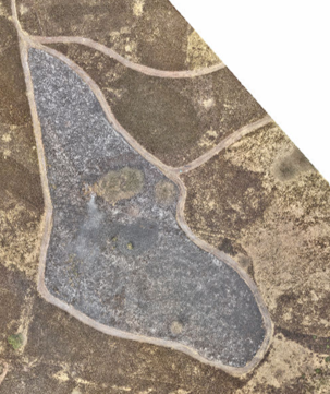
Orthophoto after the prescribed burn.
Solution
To meet these requirements, the researchers deployed the YellowScan Surveyor Ultra V2, mounted on a DJI Matrice 300 RTK UAV. The Surveyor Ultra system provided high-density 3D point clouds capable of capturing both canopy and under-canopy details.
Mission planning took one day, followed by half a day of data acquisition and half a day of initial processing in YellowScan CloudStation. Post-processing was completed in R software, where Superpixel classification enabled automated vegetation-type segmentation and precise computation of fuel consumption rates. The full workflow, including statistical analysis, was completed within two weeks.
Two flights were conducted, one before and one after the prescribed burn, each flown at an altitude of 70 meters AGL and a speed of 5 m/s, covering a 1.3-hectare heathland site. The seamless compatibility of the Surveyor Ultra with the YellowScan CloudStation and R Software ensured a consistent and efficient transition from data collection to quantitative analysis.
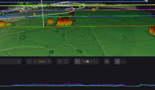
Slice depicting vegetation structure before (purple) and after (green) the prescribed burn. The vertical difference can be used as a proxy for fuel consumption.
Mission parameters
- Survey size: 1.3 ha heathland system
- Duration: Planning 1 day, acquisition 0.5 day, processing 0.5 day (full processing incl. Superpixel classification and fuel consumption rates computation in R-software: 2 weeks)
- Flights: 2 (pre-fire and post-fire)
- Flight altitude & speed: 70 m AGL at 5 m/s
- Equipment: YellowScan Surveyor Ultra V2 LiDAR system, DJI Matrice 300 RTK, YellowScan CloudStation, post-processing in R-software

Slice depicting vegetation structure before (purple) and after (green) the prescribed burn. The vertical difference can be used as a proxy for fuel consumption. It can be seen that the tree and the understory vegetation did not burn.
Results
The YellowScan Surveyor Ultra enabled precise and rapid measurement of vegetation structure before and after the prescribed burn, allowing the team to quantify fuel consumption with high spatial accuracy. Using Superpixel segmentation, three vegetation types (grassland, heather, and trees with understory vegetation) were classified with an accuracy of 97.8%.
The fuel-consumption analysis revealed clear differences between vegetation types. Heather showed the highest average reduction in height (0.165 ± 0.102 m), while grass (0.089 ± 0.088 m) and tree-understory vegetation (0.091 ± 0.068 m) exhibited lower consumption. Statistical analysis confirmed that all differences between vegetation types were significant (p < 0.001).
This methodology provides quantitative evidence for developing vegetation-specific prescribed-burning protocols and highlights the importance of collecting both pre- and post-fire remote-sensing data for effective wildfire-management strategies.
The YellowScan Surveyor Ultra enabled precise and rapid measurement of vegetation structure before and after prescribed burning, allowing us to quantify fuel consumption with ultra-high spatial accuracy.