Mapping Artificial Reefs in Coastal Waters with YellowScan Navigator

This demo, carried out with our Australian distributor Sphere Drones, aimed to demonstrate that the YellowScan Navigator could be rapidly deployed for efficient and precise coastal mapping, even in challenging public and environmental conditions. The project focused on monitoring an artificial reef located ~200 meters off Port Beach, with an emphasis on real-time usability and underwater object detection.
Challenge
We needed to prove that the system could:
- Deploy fast: Mount on a drone and be airborne within minutes, taking advantage of a narrow flight window at a busy public beach.
- See below the surface: Accurately capture the shape of the reef and spot foreign objects beneath the surface, despite turbid winter water.
- Operate with minimal disruption: Perform safely around beachgoers, with no need for restricted access zones.
- Show the advantage over traditional method: Deliver same-day 3D results, unlike diver surveys or boat-based sonar, which are slower, tide-dependent, and less adaptable.

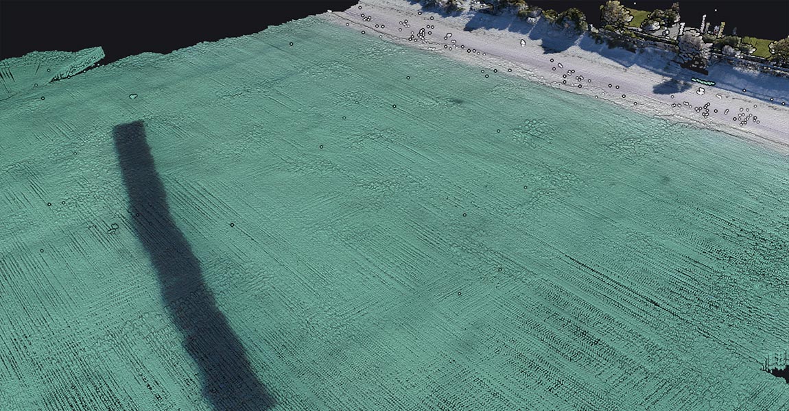
Aerial view showing the artificial reef beneath the water surface
Solution
The YellowScan Navigator, integrated with an RTRobotics drone, was selected for its compact design, embedded camera, and streamlined workflow. The full mission, including planning, flight, and data processing, was completed in less than four hours:
- 10 min for setup and mission planning
- 10 min single flight covering the full reef grid
- Under 3 h for processing in CloudStation Ultimate and TerraSolid
Despite the busy beach environment, the operation ran smoothly and efficiently. The demonstration confirmed not only the system’s ease of use and fast deployment, but also its ability to deliver high-quality bathymetric data under real-world constraints.

Pointcloud of the artificial reef

Pointcloud of the artificial reef
Mission parameters
- Survey area: 2.56 hectares
- Flights: 1
- Flight altitude and speed: 70 meters AMSL at 5 m/s
- Data acquisition and software processing times: 10 minutes and 3 hours (CloudStation + TerraSolid)
- Equipment used:
- YellowScan Navigator (with embedded camera)
- RTRobotics drone
- CloudStation Ultimate
- TerraSolid

Water depth from surface to seabed: 3 meters

Water depth from surface to top of artificial reef: 1.28 meters
Results
Point density: 47 pts/m²
Depth to seabed: 3 m
Depth to reef apex: 1.3 m
The 10-minute flight captured the full reef structure with surprising clarity, including individual modules and surrounding sand ripples, despite turbid winter water and minimal setup time.
- High-quality outputs: With ~47 pts/m², the dataset revealed detailed seabed features and matched independent depth references within ±5 cm.
- No disruption: The survey was carried out safely on a busy public beach, requiring no boats, divers, or exclusion zones.
- Scalable coverage: The workflow allows for extra perpendicular flight lines to increase point density and improve side coverage — ideal for routine monitoring or ecological studies.
- Faster than traditional methods: Unlike boat-based sonar or diver surveys, the system delivered accurate 3D results the same day.
- Positive feedback: Users praised the intuitive workflow and CloudStation processing. Some compared the data with their own reference sets and noted both quality and usability.
This demo confirmed that the YellowScan Navigator can deliver reliable, detailed bathymetric data quickly and safely, even in challenging coastal environments.


