Understanding Accuracy vs Precision in Information & LiDAR Solutions

In information analysis, measurements, and classification, especially with LiDAR solutions like those from YellowScan, the terms “accuracy” and “precision” are often confused. Although they have distinct meanings, both are essential for evaluating solution performance in fields such as UAV-based LiDAR mapping and machine learning. Understanding their difference is key to interpreting results, setting thresholds, and optimizing connectivity and reporting services. This article clarifies these concepts for measurement equipment and information classification, using real-world examples, error figures, and metrics, focusing on output quality in LiDAR workflows.
Accuracy and Precision in LiDAR Measurement Equipment
In measurement systems, accuracy and precision define the quality of sensor outputs and overall system performance.
Measurement Accuracy
Accuracy refers to how close a measured value is to a standard or true value. High accuracy means the measurement equipment yields correct results on average. For instance, a thermometer reading 100°C for an actual 100°C is accurate. In LiDAR information, high accuracy means the point cloud aligns closely with the real physical place, minimizing offset and distortion. This is often validated using Ground Control Points (GCPs).
Measurement Precision
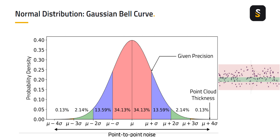
Precision measures the consistency or repeatability of readings. A solution is precise if it produces similar results under consistent conditions, regardless of correctness. For example, a thermometer consistently reading 98°C for an actual 100°C is precise but not accurate. In UAV LiDAR, precision is seen in the “thickness” of the point cloud—thin, dense, and uniform point clouds signal high-precision acquisition with minimal noise.
Key Differences in Measurement
Accuracy is about correctness; precision measures consistency. A system can be accurate but not precise, precise but not accurate, both, or neither. Understanding this distinction is essential for sound system design and is continuously refined by research and field practice.
Specific Metrics for LiDAR Measurement and Evaluation Levels
In LiDAR mapping, accuracy can be assessed at multiple levels: system-level (combining GNSS, IMU, and laser), internal precision (within a strip), and external georeferencing accuracy (relative to GCPs). Experts use distinct metrics for LiDAR output quality.
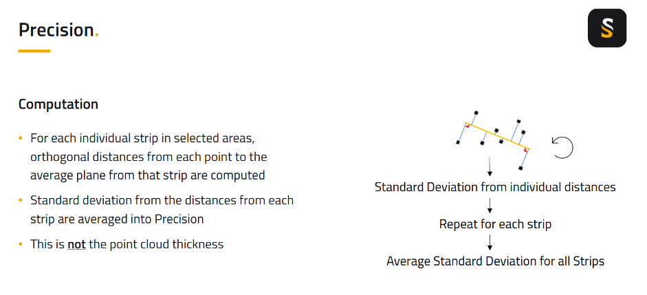
Precision (LiDAR) quantifies internal consistency within a strip, representing the standard deviation of point-to-plane distances, reflecting minimal internal noise. This highlights the inherent repeatability of the LiDAR system’s output.
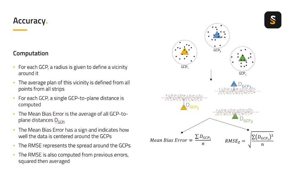
Accuracy (LiDAR) assesses alignment with real-world coordinates using GCPs. Key metrics include Mean Bias Error, which indicates a systematic offset or bias in the output. This error is crucial to identify as it points to a consistent deviation from the true position. RMSEz (Root Mean Squared Error in Z) further shows the spread around GCPs, providing a comprehensive measure of vertical accuracy.
Sources and Influence of Errors in LiDAR Implementations
Multiple error sources can affect the positional accuracy and overall quality of LiDAR data.
- Measurement Errors from Equipment Components: These include inherent errors from the LiDAR sensor itself, positional errors from GNSS (Global Navigation Satellite System), and orientation errors (Roll, Pitch, Yaw) from the IMU (Inertial Measurement Unit).
- Assembly Bias: This refers to calibration issues like misalignment between the scanner and the INS, or inaccuracies in lever arms.
- Synchronization Issues: These are computer-based errors related to the precise time alignment of different equipment components.
These errors directly impact information quality and positional accuracy. For instance, even small IMU errors (Roll, Pitch, Yaw) can cause significant positional error in meters depending on altitude and scan angle.
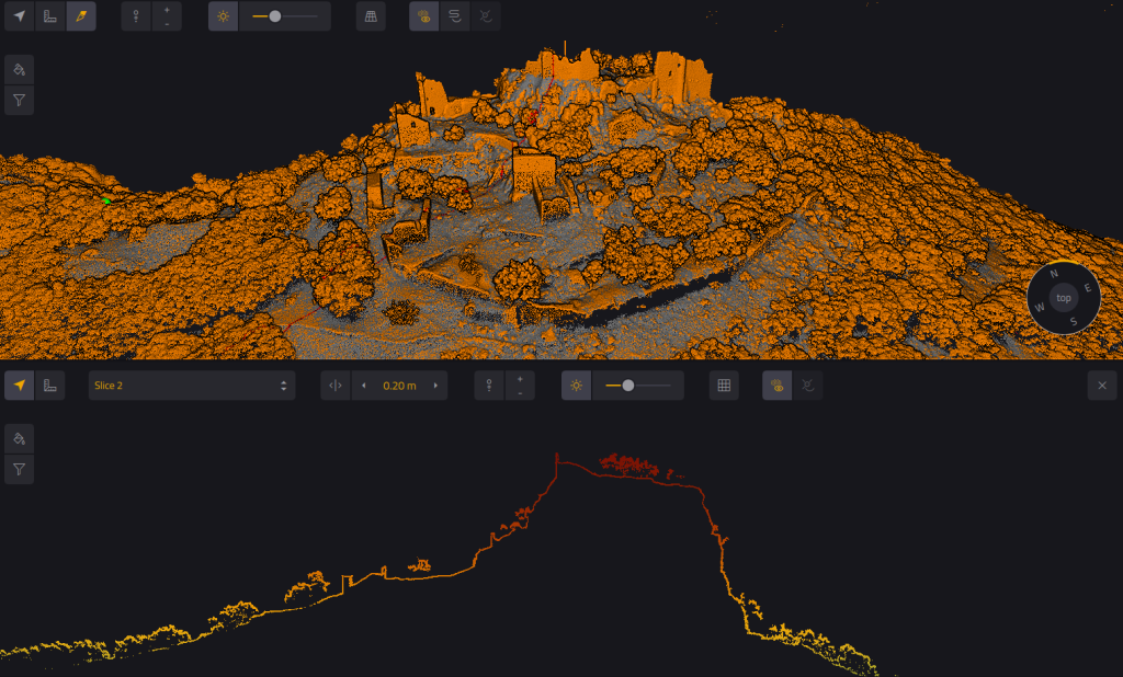
Real-World Case Study: LiDAR Measurement Quality Control in Infrastructure Design
In a large-scale infrastructure design project, accurate LiDAR measurements are essential. Calibration is paramount to ensure accurate and precise readings. Mismatch checks ensure spatial consistency between flight strips. Validating against GCPs confirms accuracy by analyzing Mean Bias Error and RMSEz to meet stringent standard thresholds. Any significant error signals potential issues, ensuring the output quality is suitable for critical design and planning tasks. This case illustrates why both accuracy and precision are essential for delivering reliable LiDAR data in infrastructure planning.
Accuracy and Precision in Information Classification and Prediction
These concepts also apply to evaluating classification models, where the goal is to make reliable predictions from input data.
Classification Metrics and Prediction
Algorithms for classification use specific metrics to evaluate prediction performance. Accuracy (Classification) is the proportion of correct predictions among all predictions. Precision (Classification) is the proportion of true positives among all positive predictions, crucial when false positives are costly. Recall is the proportion of true positives among all actual positives, important when false negatives are costly. The F1-Score offers a balance between precision and recall.
General Error Figures
Error figures help assess solution performance. Algorithms often aim to minimize a “loss” function to improve predictions. Key metrics such as MAE, RMSE, and standard deviation help assess model reliability and variability. These figures help identify if a framework suffers from low accuracy, low precision, or both.
Defining Thresholds for Classification
Classification thresholds are critical in determining the acceptance criteria for prediction results, controlling sensitivity and specificity. For example, a medical diagnostic framework’s biomarker threshold defines positive/negative results. A low threshold increases sensitivity but may reduce precision, while a high threshold increases precision but may reduce recall. Balancing these for a task is crucial for accuracy and precision. In high-stakes scenarios like political polling, high precision may be prioritized to avoid false signals in decision-making. This often requires experts to make a recommendation based on the specific task‘s requirements.
Example: Email Spam Classification
A spam filter’s task is to make predictions (“spam” or “not spam”). High accuracy means most emails are classified correctly. High precision means that when the filter marks an email as spam, it is almost always spam. Adjusting the threshold balances precision and recall, depending on whether avoiding false positives (legitimate email as spam, a loss for the user) or false negatives (spam not caught) is more critical. The nature of this task requires careful design of algorithms.
Understanding Classification Outcomes
Before evaluating performance or addressing common pitfalls, it’s essential to understand the basic outcomes in classification tasks. Predictions can be grouped into:
- True Positives (TP): correctly identified positive cases
- False Positives (FP): negative cases incorrectly classified as positive
- True Negatives (TN): correctly identified negative cases
- False Negatives (FN): positive cases incorrectly classified as negative
These values form the confusion matrix, which is the foundation for calculating key performance metrics like precision, recall, and the F1-score. These metrics help assess how well a classification model performs, especially in distinguishing between different types of prediction errors.
Common Pitfalls and How to Avoid Them
Overfitting in Classification Models: A model may appear highly precise on training information but lack accuracy on new information. This is addressed by using cross-validation and monitoring both accuracy and precision on independent test datasets. Ignoring Systematic Errors: Consistent bias in measurements or predictions reduces accuracy. Regularly check for calibration drift in measurement equipment and correct systematic errors in algorithms or information collection processes.
Smoothing feature on the CloudStation software offering users more control over the precision and clarity of their point cloud datasets.
Optimizing Performance, Connectivity, and Reporting
These critical aspects apply universally to both measurement equipment and information classification processes, ensuring the overall quality and reliability of the output.
Ensuring Reliable Connectivity
In modern measurement and classification frameworks, connectivity plays a vital role. They must communicate fast with external devices, databases, and services to collect, process, and report findings efficiently. Seamless connectivity and integration with services enable real-time monitoring and automated reporting. In RTK-based LiDAR workflows, survey accuracy depends entirely on maintaining a stable, real-time connection between UAV sensors, the base station, and the onboard system. If that connection drops, positioning data becomes unreliable, making the entire setup vulnerable, like a “house of cards.” Even when data is post-processed later, ensuring robust connectivity during acquisition is essential.
Reporting Results: Figures, Values, and Notifications
Clear reporting of figures and values is essential for stakeholders to interpret results effectively. Automated email services provide fast, timely communication. For LiDAR, automated workflows deliver inspection-ready QA/QC reports directly to experts in the office or field, improving turnaround time and decision confidence. These reports help verify data quality thresholds, flag anomalies, and document compliance with project specifications. This significantly reduces manual workload and enhances traceability, accelerating decision-making across user teams.
Best Practices for Optimization
Optimizing accuracy and precision involves calibrating measurement equipment regularly, monitoring error figures like MAE and RMSE, setting appropriate thresholds to balance sensitivity and specificity, ensuring connectivity for real-time information sharing, and reporting results clearly using figures and automated emails. The nature of information science and measurements continues to evolve, necessitating continuous improvement.
Adapting Quality to Application Needs
The required level of accuracy and precision for LiDAR output varies significantly depending on the final application, and not every mission requires millimeter-level precision. For instance, measurements for detecting power lines might tolerate different error figures compared to precise terrain monitoring for drainage design. YellowScan solutions are highly adaptable, allowing experts to adjust operational parameters and processing to meet the specific thresholds and quality requirements of diverse tasks, ensuring the optimal output for each distinct purpose.
A clear grasp of accuracy and precision is essential for professionals handling data measurement, classification systems, or analytics frameworks. While accuracy gauges closeness to truth, precision assesses consistency. Both are critical for output quality. By applying best practices, monitoring error figures, and ensuring connectivity, accuracy and precision can be optimized. YellowScan LiDAR solutions are designed for consistent, accurate measurements to fit your needs, minimizing error and maximizing trust in the output.
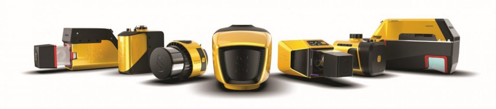
YellowScan LiDAR systems
Frequently Asked Questions
How does LiDAR ensure consistent results across different missions?
Our UAV LiDAR solutions are engineered for repeatability. You can expect stable, high-quality output—mission after mission. The design aims for low internal error.
What makes YellowScan solutions both accurate and reliable?
Integration of advanced GNSS, IMU, and laser technology allows YellowScan devices to deliver point clouds faithful to the real world and extremely uniform. That means less correction, more trust, and a fast return on investment. The system’s consistency and volume of high-quality measurements are regularly cited by experts as a key strength.
Do I need to calibrate my LiDAR equipment manually?
Our solutions include built-in calibration checks and intuitive workflows. They require minimal user intervention, ensuring optimal performance from day one. This streamlines the task and saves time.