Surprising LiDAR Penetration Capabilities Through Different Surfaces

LiDAR technology sends out hundreds of thousands of laser pulses each second. It achieves impressive accuracy between 2.5 and 10 centimeters in surveyed areas. This precision makes it a great way to get data for creating detailed 3D point clouds that serve applications of all types, from geology to urban planning.
LiDAR really shines when it comes to mapping ground surfaces under forest canopies by penetrating vegetation. The technology’s performance varies substantially with different materials. It can measure water depth effectively and see through gaps in thick foliage. But it struggles with solid surfaces like wood or dense soil. Underground detection only reaches a few centimeters in typical soil conditions.
This detailed piece gets into LiDAR’s ability to penetrate different surfaces – from vegetation and water to atmospheric conditions and ground materials. You’ll find the technology’s strengths and limitations in different environments. This helps you understand where LiDAR works best and when you might need alternative approaches.
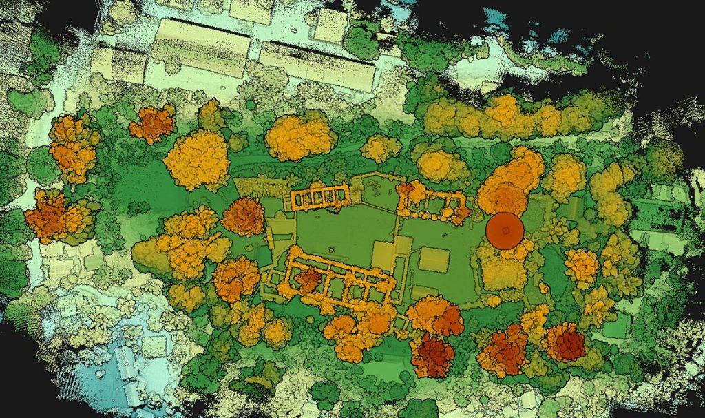
Top-down LiDAR view showing vegetation and building structures in high detail
LiDAR Technology Fundamentals and Penetration Principles
LiDAR technology works on a basic principle: it sends laser pulses to a surface and measures how long these pulses take to bounce back. This time measurement helps calculate the exact distance using a simple formula: Distance = (Speed of light × Time elapsed) ÷ 2. The system’s reach into different surfaces depends on several technical factors.
How LiDAR Wavelengths Affect Penetration Capabilities
Laser wavelength plays a crucial role in how deep LiDAR can reach into various materials. Near-infrared (NIR) wavelengths of about 1064 nm work best for mapping land, with strong reflections from plants and buildings. These wavelengths excel on land but struggle to penetrate water surfaces.
Green wavelengths at 532 nm show better results in water, making them perfect for bathymetric LiDAR systems that map underwater terrain. This wavelength strikes the right balance between water transmission and limited backscatter from underwater particles.
Ocean mapping works best at 488 nm wavelength for 61.82% of global oceans, while 443 nm covers another 14.81%. Special wavelengths matching solar Fraunhofer lines (486.134 nm and 438.355 nm) cut background light by about 70%. This reduction helps the system reach 5.0% deeper into the water.
Key Components That Determine Penetration Depth
Several key elements shape how deep LiDAR can reach:
- 1. Laser Characteristics: Pulse energy, repetition rate, and beam spread affect how deep the system can see. Higher pulse energy means better range but might raise eye safety concerns at certain wavelengths.
- 2. Material Properties: LiDAR penetrates dry, sandy, or clayey soils better than dense or rocky materials. Water content also affects penetration—wet materials absorb laser pulses and make it harder to spot objects below the surface.
- 3. Sensor Sensitivity: Better detectors can pick up weaker signals, which helps spot objects even after the pulses lose much of their energy traveling through materials.
- 4. Scanning Mechanism: The beam’s angle affects reflection quality. Steeper angles usually give better results when penetrating water surfaces.
- 5. Beam Divergence: Focused laser beams work better at penetrating tree canopies in forests.
Signal Processing Techniques for Enhanced Penetration
Modern signal processing methods help LiDAR see deeper:
Full waveform analysis captures the complete reflected laser signal instead of just single points. This method helps create detailed models of water columns, underwater features, and water clarity by studying pulse strength, echo width, and wave patterns. It helps systems see deeper by fine-tuning signal processing for weak returns in tough conditions.
Backscatter reduction methods use spatial filtering techniques from wall-penetrating radar systems. These methods cut down unwanted reflections from particles in water and improve measurement accuracy in murky conditions.
Dual frequency modulation reduces range confusion in high-frequency systems. To name just one example, see how using two frequencies (160MHz and 140MHz) with a 20MHz difference creates clearer signals in both clear and murky water.
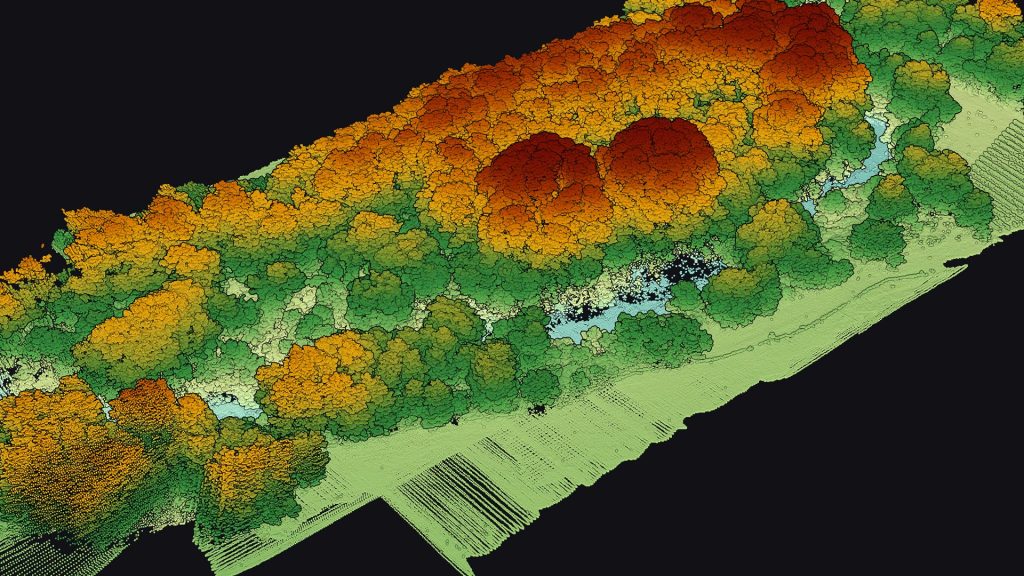
LiDAR point cloud rendering of a forested environment
Vegetation and Tree Canopy Penetration Capabilities
LiDAR systems don’t actually see through vegetation. They detect gaps in the foliage that let some laser pulses reach the ground beneath tree canopies. This difference helps us understand how the technology maps terrain under dense forest cover, where traditional photogrammetric techniques can’t identify objects hidden from direct view.
Maximum Penetration Depths Through Forest Canopies
Dense tropical rainforests let only 10% to 30% of LiDAR pulses successfully penetrate the canopy to reach the ground. The penetration rate changes based on forest type and structure. Forests with more complex structures need adjustments in LiDAR data resolution. Southern forests with simpler structures can be mapped at 25-50 meter resolutions, while the complex Pacific Northwest forests need different parameters.
Geiger-mode LiDAR has improved canopy penetration capabilities. This technology uses a photodiode array that can detect single photons, unlike traditional linear-mode systems. The system floods an area with infrared light, and each diode in the array captures individual photons that bounce back from the lit surface.
The technical advantages make a big difference: Geiger-mode flashes up to 50,000 times per second and captures 4,096 measurements per flash. This equals about 205 million samples per second. Each square meter of terrain can be sampled thousands of times in a single overflight. Multiple opportunities for laser pulses to find openings between leaves and branches improve ground detection under dense canopy.
Factors Affecting LiDAR’s Ability to See Through Vegetation
These key variables influence LiDAR’s vegetation penetration capabilities:
Pulse Characteristics and System Design
- Beam divergence: Systems with smaller beam divergence (e.g., 0.5 milliradians) produce narrower spot sizes (approximately 2 inches at canopy level). This increases the chance of finding gaps in foliage
- Return analysis: Advanced LiDAR systems can analyze up to five returns from each transmitted pulse. This helps detect multiple layers from canopy top to ground
- Pulse density: Higher densities (800+ pulses per square meter) improve ground detection rates by a lot
Environmental conditions play a vital role in penetration effectiveness. Studies show that moisture levels affect performance. LiDAR surveys right after rainfall show lower penetration rates because water on surfaces weakens laser echo signals. Current airborne LiDAR uses near-infrared wavelengths between 1000-1500 nm. These wavelengths interact differently with vegetation than green wavelengths (532 nm) used in some systems that show reduced reflectance from vegetation.
Seasons change the performance too. Deciduous forests show penetration differences between leaf-on and leaf-off conditions. Winter scans typically show higher height biases compared to spring, summer, and autumn collections. Field research shows penetration can reach 18% (6.2 meters) of average tree height in deciduous forests during summer. This increases to 24% (8.2 meters) during winter.
Ground Applications in Forestry and Conservation
Knowing how to penetrate canopy has changed multiple disciplines. LiDAR helps forest managers measure tree heights, canopy density, and ground topography accurately. This data helps plan timber harvesting, forest thinning, and overall health assessment.
Lincoln Laboratory works on something new: Doppler shift-sensing LiDAR that can detect humans under dense rainforest canopy. This system wants to identify unique human motion “signatures” different from natural vegetation movement. Current systems can detect structures but not people beneath the canopy.
Wildlife conservation benefits from canopy penetration capabilities. Detailed terrain mapping shows critical habitat features like fallen logs, water sources, and potential nesting sites that would stay hidden otherwise. This technology helps curb illegal activities in protected forests—from unauthorized logging to wildlife trafficking—by revealing hidden structures and camps beneath dense tree cover.
LiDAR helps measure ground elevations accurately in forested watersheds for hydrology and erosion control. This supports flood risk assessment and management planning. Small streams and drainage patterns that were hidden before become visible, which leads to more accurate hydrological modeling.
Point cloud of a forest without classification
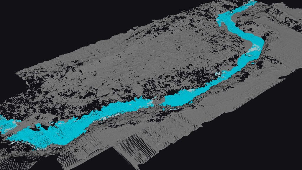
Point cloud of a forest with ground classification
Water and Snow Penetration Performance
LiDAR systems face unique challenges in water and snow environments that require special setups to reach meaningful depths. Laser pulses interact with these environments in ways that reveal both amazing capabilities and clear limitations.
Bathymetric LiDAR: Seeing Through Water Surfaces
Bathymetric LiDAR uses green laser pulses (typically 532nm wavelength) that work exceptionally well at penetrating water surfaces. Clear water barely absorbs or scatters this wavelength, which makes underwater mapping possible. Water clarity affects how deep the system can reach. The maximum depth can hit 25 meters in crystal-clear conditions. These systems usually measure depths up to three times the Secchi depth (a standard measure of water clarity).
The measurement process needs complex time-of-flight calculations because light bends as it enters water. The laser pulse creates two signals – one bounces back from the surface while the rest travels through the water and reflects off the seabed. Modern systems analyze these two returns to calculate exact depths.
Several elements affect how well the system penetrates water:
- Water turbidity (suspended sediments and algae)
- Surface conditions (waves and chop)
- Bottom reflectivity characteristics
- Laser energy output and receiver sensitivity
Snow Penetration Capabilities and Limitations
Scientists measure snow depth by comparing snow-covered and bare ground surface data. This method shows exceptional accuracy. Some systems get uncertainties less than 10 centimeters. Environmental conditions play a big role in how well these systems work.
Tests with iPhone LiDAR modules on consumer drones produced great results. They achieved root-mean-square errors of just 3 cm and absolute mean errors of 2.5 cm in snow depth measurements. Even advanced systems struggle sometimes. The 1550nm wavelength has more trouble with snowfall than the 905nm wavelength.
Forests create additional challenges. Research reveals much higher errors in forest areas compared to open fields. A study found mean absolute deviation (MAD) values of 0.96 cm in fields but 9.6 cm in forests.
Case Studies in Hydrological and Glacial Mapping
Glaciologists love LiDAR because it collects detailed data over large areas quickly. The technology captures tiny ice surface features with accuracy close to 10cm.
LiDAR systems excel at spotting specific glacier features. They reveal crevasses, moraines, melt streams, and moulins (sink-holes) that other methods miss. Scientists now track glacier movement with amazing precision. Helheim Glacier’s terrestrial laser scanning (TLS) can track even the smallest features both manually and digitally.
Real-world applications show LiDAR’s value. It provides essential data that models glacio-hydrological processes better than ever before. Airborne LiDAR offers budget-friendly solutions for glacier mapping tasks like mass balance monitoring.
Bathymetric point cloud made with YellowScan Navigator
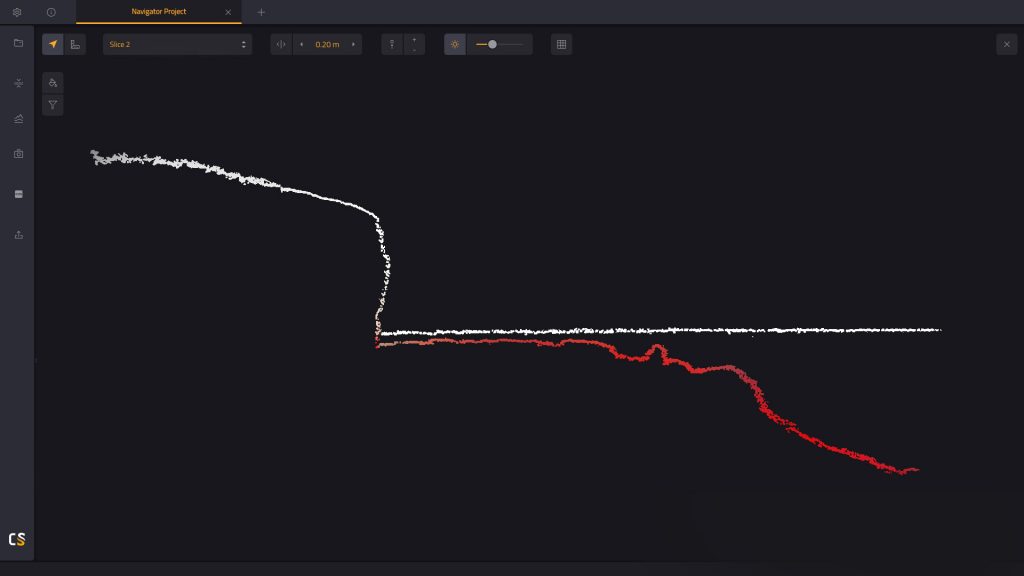
Slice of the bathymetric point cloud showing the underwater ground
Atmospheric Penetration Through Fog, Rain and Clouds
Weather creates big challenges for LiDAR sensors. Atmospheric conditions like fog, rain, and snow affect performance through different physical mechanisms. Latest sensor technology advances haven’t eliminated these environmental roadblocks that matter a lot for ground applications.
How LiDAR Penetrates Different Weather Conditions
Bad weather affects LiDAR performance through three mechanisms: absorption, scattering, and reduced surface reflectivity. Rain reduces LiDAR effectiveness in two ways. The point clouds (NPC) decrease because laser pulses bounce off raindrops before hitting targets. Distance accuracy suffers when pulses hit precipitation and return too early.
LiDAR wavelengths react differently to atmospheric conditions. 1550nm wavelength systems offer longer range in perfect conditions but might lose this edge in bad weather. The AEye 4Sight M sensor uses 1550nm wavelength and shows remarkable toughness against various rain intensities. Its high laser output power helps maintain stable point cloud numbers through better penetration.
System design makes a big difference in weather resistance. The atmospheric lidar on the EarthCARE satellite shows specialized design at its best. It shoots ultraviolet laser beams and uses smart detection methods to tell different types of scattering apart. The receiver breaks down backscattered signals into three channels. This helps measure particles and molecular interactions separately.
Comparing Performance in Clear vs. Foggy Environments
Clear and bad weather conditions show stark differences in performance. Heavy rain at 25mm/hr cuts LiDAR range by 15-20%. Fog proves worse with a 50% reduction. Linnhoff’s team ran a six-month study that backs this up. They found sensing started failing at 10mm/h rainfall, and target detection stopped at 50mm/h.
LiDAR technology sometimes outperforms human vision and cameras in fog. The link between visibility and performance isn’t always straightforward.
Autonomous Vehicle Applications in Poor Visibility
Autonomous vehicles need reliable LiDAR in bad weather. Deep learning shows promise here. Research proves that training on bigger datasets from clear conditions works just as well in all weather types. This challenges the belief that systems need adverse weather training data.
Better signal processing helps too. Full waveform analysis helps self-driving systems understand signals in tough conditions. Many manufacturers have created special algorithms. These filter out rain, fog, and dust from point clouds. The results look good for improving perception and detection accuracy.
The future points to sensor fusion rather than single-sensor solutions. This gives vehicles the best environmental awareness in any condition. LiDAR works with radar and other sensors to cover individual weaknesses in bad weather.
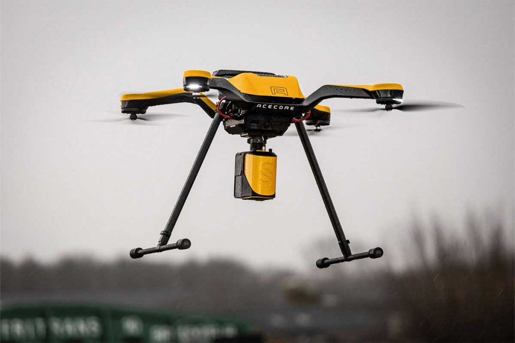
Drone equipped with YellowScan Mapper LiDAR system for aerial mapping
Ground and Solid Surface Penetration Limitations
LiDAR excels at mapping surface features, but questions persist about what lies beneath. Solid surfaces pose unique challenges that set them apart from vegetation or water when it comes to laser penetration.
Can LiDAR See Underground? Debunking Common Misconceptions
People often think LiDAR technology can “see” underground just like it maps terrain beneath forest canopies. This comparison doesn’t hold up to scientific scrutiny. Light waves behave differently underground – laser pulses that LiDAR uses bounce off or get absorbed by ground surfaces.
The science behind this makes sense. Trees and vegetation have gaps that let some pulses reach the ground. Soil and rock create solid barriers. Light hitting these surfaces gets absorbed or reflected, and barely any passes through. The tiny amount that does penetrate sends back signals too weak for standard LiDAR equipment to detect.
Research shows that standard LiDAR systems can only reach a few centimeters into soil. This makes underground mapping with LiDAR impractical. Claims about LiDAR’s underground mapping capabilities don’t match reality.
Sand and Soil Penetration Capabilities
Different materials allow different levels of penetration. Dry soil lets light penetrate better than dense or rocky materials. Here are the main factors that determine how deep LiDAR can reach:
- 1. Soil moisture content: Water absorbs laser pulses and reduces their strength, which makes finding objects underground harder
- 2. Material density: Less compact materials let light go slightly deeper
- 3. Sensor sensitivity: Better sensors might catch faint signals from deeper layers
Calibration and data processing algorithms help boost mapping accuracy despite shallow penetration. Even specialized commercial LiDAR systems rarely go beyond a few centimeters into typical ground surfaces.
Alternative Technologies for Subsurface Mapping
LiDAR’s underground limitations have led to better subsurface mapping options:
Ground Penetrating Radar (GPR) leads the pack. GPR uses radar pulses instead of light to create images of what’s underground. This gives clearer pictures of buried features than other methods.
The “Exodigo” system shows what’s possible with modern technology. It combines GPR, electromagnetic surveying, magnetic technology, and high-resolution 3D imaging with AI processing. This creates detailed underground maps without digging, finding both known and hidden utility lines.
Electromagnetic methods work best for finding conductive materials like metals and certain minerals. Resistivity imaging tells materials apart based on electrical resistance. Seismic surveys reach deeper than GPR but don’t show as much detail, making them ideal for mapping larger geological structures.
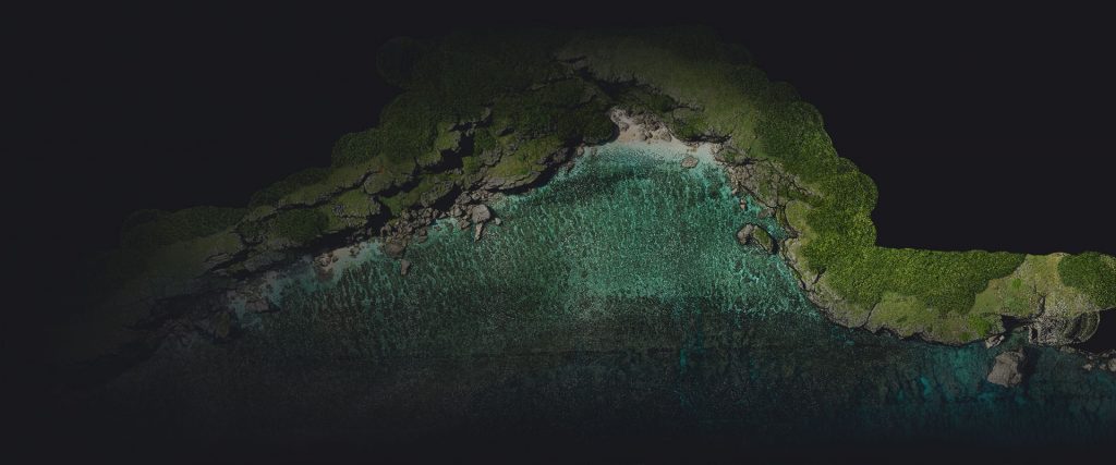
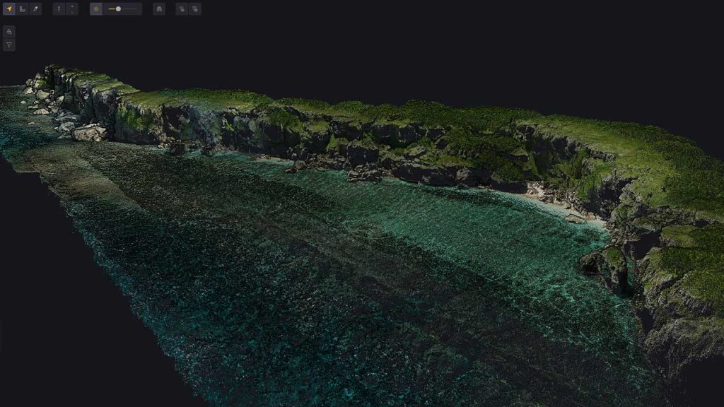
Coastal area point cloud mapped with bathymetric LiDAR data system
Key Takeaways on LiDAR Penetration Capabilities
LiDAR technology works well on surfaces of all types, but its ability to penetrate varies by a lot based on material properties and environmental conditions. Modern LiDAR systems use specialized wavelengths and advanced signal processing to achieve impressive results. These systems can penetrate up to 25 meters in clear water and detect ground surfaces through thick forest canopies with 10-30% success rates.
Basic physics principles create some unchangeable limits. Solid surfaces block laser penetration almost completely, which means ground penetration only reaches a few centimeters. Weather plays a huge role too. Heavy rain cuts down the effective range by 15-20%, and dense fog can reduce capabilities by up to 50%.
LiDAR shines in specific uses while showing where we need other technologies to get the job done. The technology excels at bathymetric surveys, forest structure analysis, and atmospheric monitoring. Subsurface mapping needs different tools like Ground Penetrating Radar or electromagnetic methods.
Professionals who know these strengths and limits can pick the right tools they need. LiDAR technology keeps getting better, especially in signal processing and sensor sensitivity. This expands what it can do while working within physical limits.
Frequently Asked Questions
How effective is LiDAR at penetrating different surfaces?
LiDAR is highly effective at penetrating certain surfaces, particularly vegetation and water. It can create detailed 3D maps of areas with dense vegetation and penetrate up to 25 meters in clear water conditions. However, it cannot penetrate solid surfaces like ground or walls beyond a few centimeters.
Can LiDAR see through tree canopies?
LiDAR doesn’t actually “see through” canopies, but it can detect gaps in foliage, allowing some laser pulses to reach the ground beneath. In dense tropical rainforests, typically 10% to 30% of LiDAR pulses successfully penetrate the canopy to reach the ground.
How does weather affect LiDAR performance?
Weather conditions significantly impact LiDAR performance. Heavy rain can reduce the effective range by 15-20%, while dense fog can cause up to a 50% reduction in capability. However, some LiDAR systems can perform better than human vision in certain foggy conditions.
What are LiDAR's limitations in underground mapping?
LiDAR has severe limitations for underground mapping. It can only penetrate soil by a few centimeters at most, making it impractical for subsurface mapping. Alternative technologies like Ground Penetrating Radar (GPR) are more effective for underground visualization.
How does LiDAR perform in water environments?
Bathymetric LiDAR, using green laser pulses (532nm wavelength), can effectively penetrate water surfaces. In exceptionally clear conditions, it can reach depths of up to 25 meters. However, factors like water turbidity, surface conditions, and bottom reflectivity can limit its effectiveness.