Mapping Mountainous Regions for Forestry Management

Challenge
Following a successful research and development collaboration with a government agency, our customer GeoAerospace obtained a contract to perform airborne LiDAR capture in various forestry sites along the secluded west coast of Ireland.
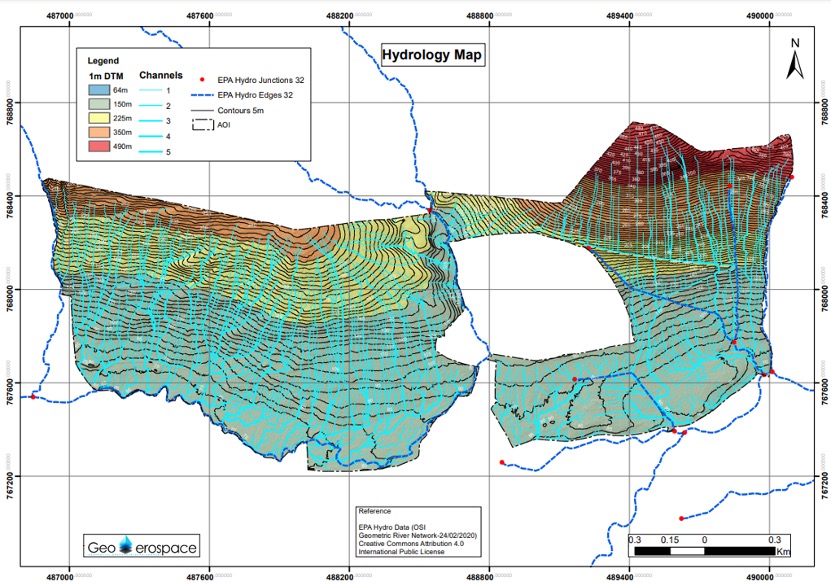
Their primary objective was to acquire high-quality airborne LiDAR data, as it is crucial for mapping remote mountainous regions as part of forestry management surveys. This data plays a vital role in generating accurate terrain models for hydrological analysis, enabling the mapping, identification, and quantification of river channels concealed beneath dense canopy cover.
Given the distinctive terrain characteristics, the survey presented significant challenges to access the sites using conventional survey aircraft. The vast scale of the areas and the rugged, remote mountainous terrain made ground-based surveys impractical.
Solution
In response, GeoAerospace was given the task of collecting LiDAR data across multiple sites with their YellowScan Surveyor Ultra. The goal was to generate terrain models and assess the hydrological morphology at each location. To tackle the complexities of the environment and adverse weather, drone surveys using automated terrain-following were used at specific sites. This approach ensured accurate and homogenous data collection as well as analysis under challenging circumstances.
As part of their long-term business strategy, GeoAerospace aims to provide added value to their clients through the data they collect. They effectively used the vegetation penetration property of LiDAR, and the multi-echo capability, to map in detail the vegetation levels and then incorporating it into forestry inventory processes, offering an additional service to their clients.
This initiative proved to be very successful in establishing streamlined workflows for generating tree maps, enabling detailed forestry inventory assessments at scale, on thousands of individual trees. Key attributes such as tree height and crown spread were accurately measured, providing valuable insights to support effective forestry management.
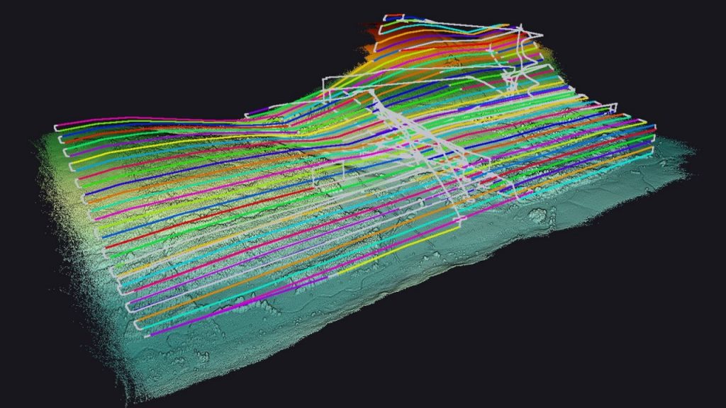
flight plan of the area (around 300 hectares/750 acres)
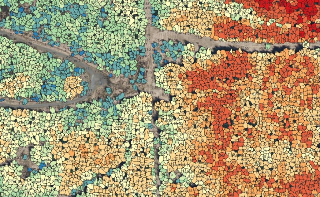
Tree Map with tree height and crown diameter for 1000’s of individual trees
Mission parameters
- Survey size: Several sites – all approximately 300 hectares (750 acres)
- Duration:
- 1-2 days of flight planning (per site) due to the complexity of access to each take-off and landing point and to secure landowner permissions
- 1-2 days on site (per site) due to mobilization and access issues to various locations to maintain line-of-sight operations
- Number of flights: Approx. 8 x 20-minute flights per site
- Flight speed and altitude: 70m AGL (terrain following via UGCS) 10m/s
- Equipment: Yellowscan Surveyor Ultra LiDAR system
- Drone: DJI M300
- Trajectory Correction: PPK using CORS station operated by Ordinance Survey Ireland
Results
- Point density: 200+ points per meter
- Accuracy: 5cm
- Digital Surface Model & Digital Terrain Model (5cm GSD)
The aerial LiDAR data provided valuable data that would have been challenging to obtain using alternative methods due to the large size and remote, densely forested locations of each site. This data was acquired in a cost-efficient and timely manner.
Apart from the standard pointcloud, contours, DSM (Digital Surface Model), and DTM (Digital Terrain Model), GeoAerospace were also able to provide client-specific deliverables derived from the LiDAR data. These included a suite of additional maps such as slope, aspect, elevation & hydrology.
The high-quality LiDAR data and dense pointclouds enabled a thorough analysis of the terrain underneath the canopy, leading to precise hydrological assessments of the landscape. Compared to alternative methods like ground-based surveys, their approach significantly reduced acquisition time, cost, and on-site duration.
Given the requirement to fly their survey aircraft at 500m (1500ft), within the range of the aircraft’s LiDAR, and the challenges posed by navigating mountainous terrain, it was deemed unsafe to fly the aircraft into the valleys.
Fortunately, according to GeoAerospace, having access to excellent drone-based LiDAR data allowed them to deliver data of equal accuracy and standards, but with a higher point density. They also put the emphasis on the exceptional efficiency with which their YellowScan LiDAR solution and CloudStation deliver data, meeting the high standards set by many of their clients.
They further highlight that, although specific support wasn’t requested for this project, YellowScan consistently provides efficient, timely, and high-standard support.
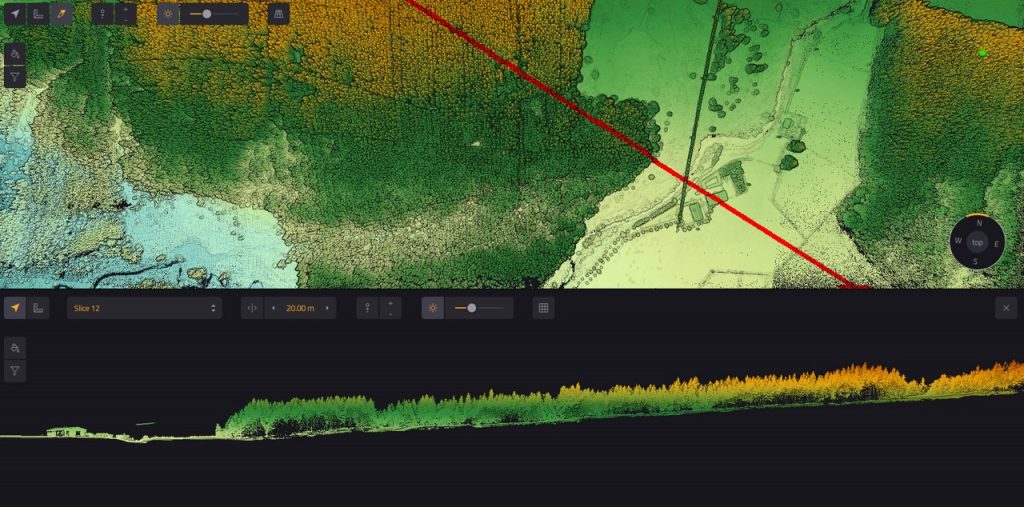
Cross section through forestry
The sites presented several challenges in terms of access to high mountainous valleys for our survey aircraft, so some sites required automated terrain following drone surveys due to the complex terrain and difficult weather environments. So having access to high-quality drone-based LiDAR data enabled us to deliver the required data of equal standard/accuracy with greater point density. The deployment speed of our YellowScan LiDAR system is often faster than that of our survey aircraft. This swift deployment is crucial in time-critical survey scenarios.

Fearghus Foyle
Managing Director – GeoAerospace
