Drone Flight Planners: Integrating LiDAR & UAVs

Introduction to Flight Planners
A LiDAR drone is an unmanned aerial vehicle (UAV) equipped with Light Detection and Ranging (LiDAR) sensors. A LiDAR is an active sensor that uses inertial measurement to correlate where it is on the earth’s surface, resulting in a direct measurement of the earth. These measurements are visualized in a 3D point cloud that enables the creation of highly accurate and detailed 3D maps and models for various applications. LiDAR drones offer several advantages over traditional surveying methods, including cost-effectiveness, time efficiency, and the ability to capture data from inaccessible or hazardous areas.
Data precision is important in LiDAR data collection, as the data and derived data products need to meet high-quality standards. The term precision is often used interchangeably with accuracy, but they don’t mean the same thing. Accuracy refers to geographical precision, while precision is the repeatability of a measure. In LiDAR for drones, a precise system will output a very thin point cloud, with little “noise” (a term that refers to variation and irregularity inside the point cloud). The latest LiDAR sensors can improve precision by combining the strengths of different positioning technologies.
Flight planners or flight apps are software programs that enable planning, executing, and monitoring automated drone flights from a computer or mobile device. They typically include a list of settings and instructions that guide a drone through a flight mission. Compared to manual flight planning, flight apps enable quick and accurate drone flight planning, allow a drone to function autonomously, and execute high-capacity work efficiently, accurately, and safely. Flight planners are one of the reasons why drone mapping offers significant advantages in terms of cost, speed, and accuracy, compared to traditional survey methods.
The Benefits of Flight Planners in LiDAR Surveys
Advanced flight planners combine standard flight planning tools with application-specific functionality that helps streamline the various pre-flight preparations for LiDAR surveys. A drone flight plan for a LiDAR survey is a determined combination of instructions, including coordinates, speed, altitude, direction, heading, and more, that serve the purpose of guiding a drone in accomplishing a flight and capturing mapping data. Flight planners typically include pre-flight checklists, route planning, 3D terrain analysis, airspace rules compliance checking, and weather monitoring features.
Example of features
For comprehensive LiDAR surveys, advanced flight planning software offers application-specific features such as optimized routing, altitude adjustments, and overlap configurations to maximize data coverage. This way, potential challenges of drone-based LiDAR such as limited range and resolution can be met.
Another core feature of flight planners for mapping purposes is waypoint flight planning, where the user can draw a target area on a map using points, lines, and polygons, as well as monitor the drone’s real-time position during the flight. Drone waypoint paths follow an irregular pattern based on the unique characteristics of the area of interest, but drones can also follow a grid pattern or grid path. A flight planner lets users manually select waypoints for the drone to fly over or designate a coverage area and design a suitable flight pattern.
Optimising data accuracy and flight paths
By defining precise flight paths, data accuracy is ensured by using a flight planner: LiDAR data accuracy depends on the flight speed and flying altitude, which can be managed both by a flight planner. Using elevation maps to plan a precise flight path, the drone can follow or adjust to the terrain height during the flight so that a constant flying height is maintained at all times during the entire flight path, which guarantees data consistency and accuracy.
Flight planners can quickly find the optimal flight path to save time in the field while covering the largest area possible while making optimal use of a drone’s battery life. Because a flight planner can take into account many parameters at once and optimize performance based on all of them, overall efficiency is improved and mission time in the field is reduced.
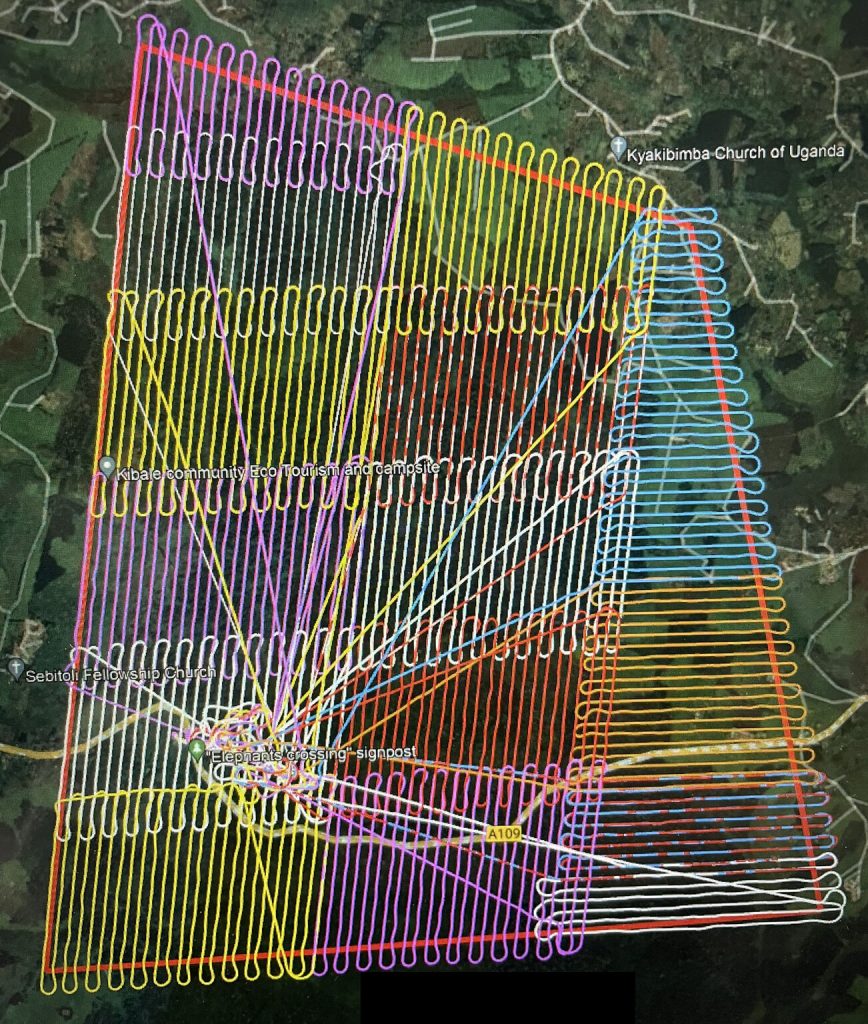
Flight plan over 2 500 hectares of rainforest in Uganda with a Quantum-Systems VTOL Trinity F90+ drone equipped with a Qube 240 lidar (processed in the YellowScan CloudStation). © L’Avion Jaune
Seamless Integration of Flight Planners with LiDAR Systems
Flight planners are software programs that typically do not come packaged with a commercial-of-the-shelf drone, so they need to be purchased and downloaded separately. Flight planners are generally available in two versions: commercial off-the-shelf (COTS) solutions and custom-made solutions. COTS provide a basic level of functionality and are made available directly from software vendors, whereas custom-made solutions are created to meet specific market needs and requirements, including mapping and navigation. These are also known as advanced flight planners because they offer advanced functionality for specific applications, such as LiDAR applications.
Integration with LiDAR Systems
To meet the requirements of LiDAR industry applications, flight planning developers closely collaborate with different LiDAR system providers so that hardware and software are well-integrated. For end users, this means for example the flight planner has an in-built LiDAR toolset to calibrate the drone’s IMU and gather precise and accurate LiDAR point clouds. Such a toolset also allows them to select their LiDAR sensor of choice to make sure the individual capacities of that sensor are exploited during the drone flight.
The synergy between advanced flight planners and LiDAR systems also results in customization options for specific LiDAR applications, such as complex vertical scans (such as capturing building facades, or rock cliffs), area scans or corridor mapping (rivers, powerlines). Compatibility and optimization for different LiDAR survey scenarios are offered through flight planning according to a specific Field Of View (FOV), the inclusion of figure-eight calibrations during missions to improve the drone’s accuracy, and how the drone makes turns to guarantee data accuracy.
Example: UgCS
One such COTS solution for LiDAR mapping is UgCS, a ground control software for drone mission planning and flight control. It was developed by SPH Engineering, a drone technology developer. UgCS supports the most popular drones and includes features such as LiDAR survey planning with automatic IMU calibrations, full 3D terrain following and built-in photogrammetry, corridor and vertical scan tools. It is used for applications such as LiDAR, vertical inspections, photogrammetry, powerline inspections and live video streaming surveys.
The UgCS toolset for LiDAR mission planning helps to reduce human errors and unlock the full potential of LiDAR. To do this, a pilot is required to calibrate the IMU properly (typically at least two times per flight). While different LiDAR manufacturers recommend different calibration patterns, UgCS does support the most popular calibration patterns including the Eight figure and U-Shape.
In addition to calibrating the IMU, a drone pilot needs to maintain correct flight height and line spacing between scans to ensure coverage and point density, and make sure the right drone turns and line scanning to minimize IMU error accumulation and excessive shaking of LiDAR above the area of interest. The FOV should be specified manually by the pilot, and both FOV and altitude affect line spacing. Both are separate parameters to be entered by the user into the flight planner, among multiple other ones that are self-explanatory.
Key benefits
Customers who have used UgCS for LiDAR-based mapping mentioned key benefits that include multi-mission programming and intuitive mission configuration to get up-and-running quickly. The ability to upload custom DTMs and geometries in KML format is particularly useful for high-resolution surveys, as well as a stable Wi-Fi connectivity between the computer running the flight planner and the drone. Fully autonomous LiDAR flights are now possible from take-off to landing thanks to a newly embedded initialization figure.
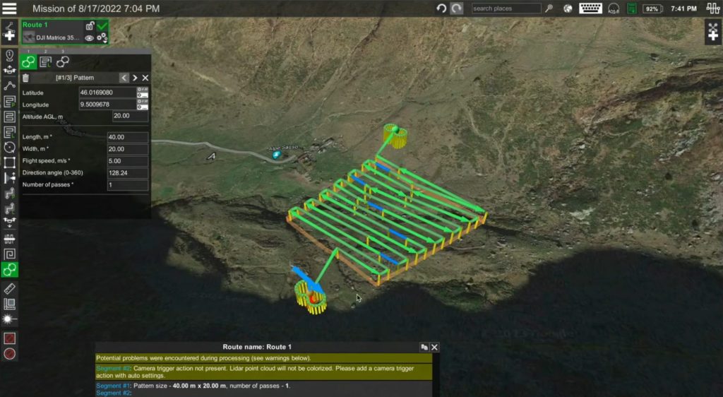
Capture of UgCS flight planning software © UgCS
Future Trends and Innovations
Because of the advantages LiDAR drones offer over traditional surveying methods, the adoption of LiDAR drones across different industries is expected to grow in the coming years. The adoption of drone-based LiDAR in different industries, such as construction/surveying, infrastructure, urban planning, transportation, forestry/environmental, has been huge and will continue to grow. The rising popularity of autonomous vehicles and the need for high-resolution mapping data will also benefit the LiDAR drone market.
The existing synergy between software vendors of advanced flight planners and LiDAR system manufacturers will benefit the further integration of both hardware and software to facilitate LiDAR data capture for new industry applications for different markets. Advancements in LiDAR technology, such as lighter and more compact LiDAR sensors, improved flight capabilities of drones, and the integration of software for data processing and analysis, will further propel market adoption. These technological advancements are likely to find their way to advanced flight planners to exploit the possibilities of new LiDAR sensors as much as possible, to capture and process as much high-quality LiDAR data in a short amount of time, further driving efficiency.
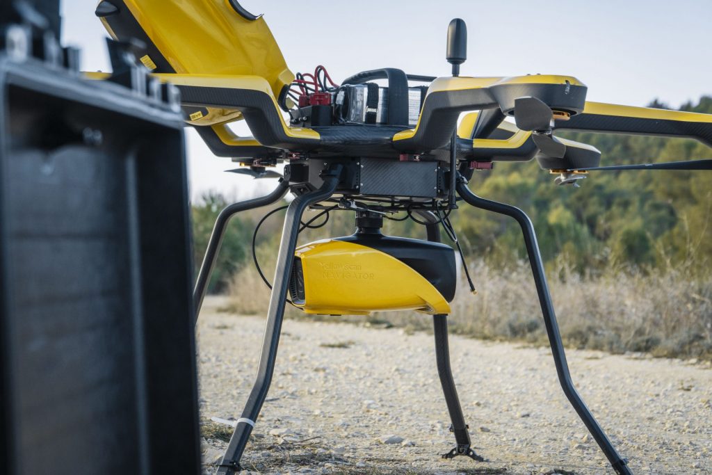
YellowScan Navigator LiDAR system mounted on the Acecore Noa UAV
Conclusion
This article discussed the crucial role of flight planners in optimizing LiDAR surveys for drones. Flight planners are software applications that provide the necessary tools for drone pilots to plan and execute their flights with greater accuracy, efficiency, and safety. An advanced flight planner, such as SPH Engineering’s UgCS mission planning and flight planning software, offers additional functionality for efficient drone LiDAR data collection and streamlines pre-flight preparations for LiDAR-equipped drones, for example through specific LiDAR tools including terrain following and IMU calibration at set time and distance intervals during the flight. Because of the many benefits that advanced flight planners offer for drone LiDAR projects, including enhanced data collection and efficiency gains, their use is highly encouraged for your next drone LiDAR survey.
Frequently Asked Questions on flight planners
What is a UAV flight planner, and why is it essential for LiDAR surveys?
A flight planner is a software tool designed to plan, execute, and monitor automated drone flights. It plays a crucial role in LiDAR surveys by ensuring precise and efficient data collection, optimizing the overall survey process.
How do flight planners enhance pre-flight preparations ?
Advanced flight planners go beyond standard tools, offering application-specific functionality that streamlines pre-flight preparations. This includes optimizing flight paths, adjusting parameters for specific LiDAR sensors, and ensuring compliance with survey requirements.
What features should I look for optimal survey performance?
When choosing a flight planner, consider features such as compatibility, ease of use, real-time monitoring capabilities, and the ability to customize flight paths. These features contribute to more accurate and efficient LiDAR data acquisition.
Can a flight planner for LiDAR surveys help in ensuring safety and compliance with regulations?
Yes, many flight planners incorporate safety features and regulatory compliance tools. These may include geofencing to restrict drone movement, pre-flight checklists, and integration with airspace information to ensure safe and legal survey operations.
How does the integration of application-specific functionality benefit LiDAR surveys with UAVs?
Application-specific functionality in UAV LiDAR flight planners caters to the unique requirements of LiDAR surveys. This can include automatic terrain following, point cloud preview, and tools for adjusting flight parameters based on the specific characteristics of LiDAR sensors used, ultimately optimizing data collection.