Can LiDAR be used underwater, and how effective is it

How does laser scanning work underwater? How can a laser penetrate water?
What are the main benefits and challenges when using this technique? What happens when a laser pulse hits the water? This and more is explained in the following article about bathymetric LiDAR.
Measuring underwater depths
People have studied the underwater depth of river, sea, and ocean floors for thousands of years to be able to safely navigate boats through the water. Today, such depth measurements are done using advanced technology that includes either sound (sonar), or laser pulses (LiDAR). The study of underwater topographies is called bathymetry, whereas studying underwater depths is known under terms such as seafloor mapping or imaging.
This article covers bathymetric LiDAR, a specialized form of LiDAR to perform bathymetry that uses water-penetrating LiDAR to measure underwater topography accurately. LiDAR-based bathymetry is performed using an airborne bathymetric LiDAR system that is mounted on an airplane, helicopter, or unmanned aerial vehicle (UAV) to measure the depths of relatively shallow coastal and inland water bodies. The technique has been around since the 1970s and was originally used in the Cold War for submarine detection. Since then, the technology has advanced which led to various new applications.
How does bathymetric LiDAR work?
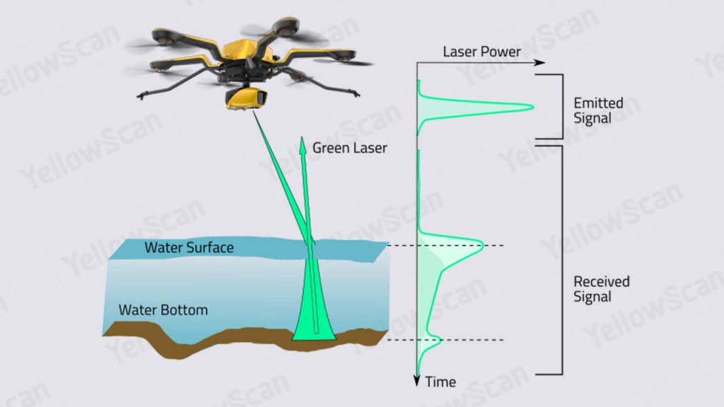
Bathymetric LiDAR uses green laser pulses. These enable the measurement of the distance from the water’s surface to the seabed. From a flying platform, a laser scanner emits green radiation that passes through the water and is reflected on the bottom of the seabed. The laser scanner collects the reflected radiation of the pulse and calculates the time elapsed between the emission and reception to obtain the distance to both the water surface and seabed.
This is, in a nutshell, how bathymetric LiDAR collects depth information and determines where the water surface is located. Let’s have a closer look at the path of a laser pulse emitted from a laser scanner to understand better what happens after a laser pulse hits the water.
The path of a laser pulse: shoot, hit, and return
A strong and short laser pulse with a wavelength of 532 nm (green light) is shot from a LiDAR at a high frequency (5,000-500,000 shots per second). When light enters the water it is refracted, which means that the angle changes. Additionally, the light gets scattered and absorbed by the water before it hits the water’s bottom.
If the water is transparent enough, the laser strong enough and the bottom is not too deep, some of the light hits the water bottom and reflects on it. The type of bottom has a big influence on the reflectivity. For example, white sand reflects more light than a dark layer of mud which absorbs most light.
The same bathymetric LiDAR sensor that emits the pulses detects reflected light photons. The LiDAR sensor digitizer converts detected photons to digital signals, which results in a detailed waveform for each pulse. The moment the laser pulse hits the water surface and the water bottom can be deducted from the waveform, while the depth of the water bottom is derived from the time difference between hitting the water surface and the seabed. This information is useful for many different applications.
Applications in Bathymetric Mapping
As stated above, bathymetric LiDAR was first used to detect submarines. However, many more applications have been developed that use bathymetric LiDAR as a result of advancing sensor technology. With smaller platforms including unmanned drones and small helicopters that can carry heavier payloads, bathymetric LiDAR systems can cover large areas quickly and capture accurate 3D data that includes the seabed and surrounding terrain of different water bodies. Here are three popular applications that use bathymetric LiDAR:
Coastal management and habitat mapping
For this application, high-resolution data of the underwater environment is used for planning coastal infrastructure projects, ensuring sustainable development, and preserving the ecological balance of coastal ecosystems.
Hydrographic surveying
Bathymetric LiDAR technology offers rapid, accurate, and cost-effective data collection for hydrographic surveying, which involves measuring the physical features of water bodies (depth, currents, and underwater topography).
Underwater archeology
Using bathymetric LiDAR, submerged archeological sites are found and studied, such as ancient shipwrecks and submerged settlements.
This is only a small sample of current applications using bathymetric LiDAR. Additional applications include flood risk analysis and planning new infrastructure investments. Bathymetric LiDAR can also be used as a substitute for surface vessels in inaccessible areas such as shallow, remote, or obstructed sites.
Advantages and Challenges in Deploying LiDAR for Bathymetric Surveys
Over time, bathymetric LiDAR has proven to be a fast, reliable, accurate, and safe technique for rapidly mapping nearshore waters, beaches, coastal engineering structures, and more. Compared to traditional methods, such as sonar-based systems or manual depth soundings, bathymetric LiDAR can generate more detailed and precise maps of underwater topography. It also allows for seamless mapping of both water and surrounding land, with the ability to reach up to three times the visible water depth.
The advantage of using green light for bathymetric LiDAR is that it penetrates further into the water than other frequencies, to capture deeper depths that standard bathymetry methods may miss. Green light also scatters less off suspended particles than other wavelengths, reducing inaccuracies caused by suspended sediment or algae in the water column.
Bathymetric LiDAR is also a more sustainable and safer option for underwater mapping as it doesn’t require expensive and fuel-consuming survey vessels, or people entering the water. These might get lost or injured during surveys, while the use of bathymetric LiDAR sensors eliminates such potential risks.
However, there are also challenges when choosing bathymetric LiDAR over traditional surveying methods. Dealing with a dynamic medium such as water means there’s no one-size-fits-all solution for each and every project: how deep you can measure depends on the local water transparency and turbidity, bottom reflection, and the strength of the laser pulse.
Exploring underwater depths and ground topology
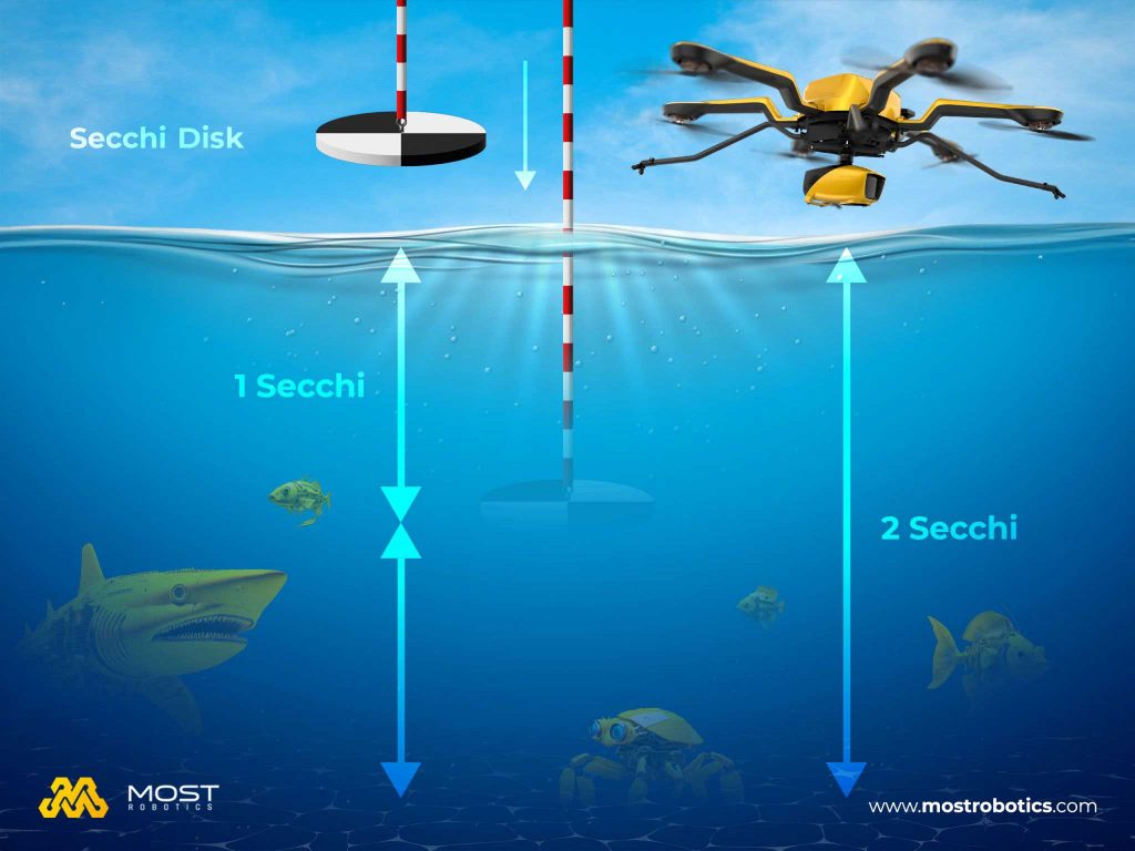
The YellowScan Navigator topobathymetric system is a great example of how bathymetric LiDAR keeps advancing. This innovative solution for exploring underwater depths and ground topology with a single-button operation has been designed for conducting bathymetric measurements in shallow waters and is rapidly deployable on a UAV. It covers various water systems such as shorelines, rivers, lakes, ponds, seas, oceans, gravel pits, and more. The maximum water depth that can be measured using the Navigator is 2 Secchi depths.
Being a full waveform LiDAR system, it captures more data than discrete return LiDAR systems, which ensures continuity between underwater points and the surrounding terrain, resulting in a seamless mapping process ideal for applications such as coastal erosion, habitat monitoring, flood risk modeling, and more.
The topobathymetric system, combined with the YellowScan Cloudstation software, streamlines data analysis for precise bathymetric mapping without sacrificing accuracy. Offering automated surface detection, water classification, underwater point correction, and seamless depth measurement, it offers everything you need to make your bathymetric LiDAR workflow more productive and efficient.
Read more about the YellowScan Navigator, the latest bathymetric and topographic LiDAR solution.