Using UAV LiDAR for a reforestation project in Indonesia

Masarang Foundation, a 20-year-old ecological organization founded by world-renowned forester Dr. Willie Smits and based in North Sulawesi, Indonesia, has reforested 35 million trees to date. As forests are an essential source of clean water, air, and food for the surrounding communities, Masarang Foundation’s reforestation efforts have had a significant impact on the region’s well-being. In line with their mission, the association had most recently acquired 500 hectares (1235 ac) of degraded grasslands, secondary forests, and coastline to restore and conserve.
Challenge
Given the extensive area and moderately challenging terrain, conventional topographic surveys were deemed too time-consuming and costly. To expedite the mapping process, LiDAR was identified as the ideal solution. Furthermore, the pronounced relief of the terrain would have posed significant challenges for ground-based acquisition due to restricted access and risks in certain areas. The project’s aim was also to establish a natural carbon sink while generating food and fuel from the forest, thereby creating a robust economic foundation for the community.
Solution
MSDI was contacted by Masarang Foundation to organize LiDAR scans for topographic and hydrologic analysis of the area in order to create a master plan. They carried out LiDAR surveys over 500 ha (1235 ac) to establish a 3D plan of the hills for an optimal management of the new shrub plantations and thus to optimize the distribution and growth of the different species of re-planted trees. These scans allowed for the most efficient use of resources and helped to increase the success rate for forest maturity.
Masarang Foundation was then able to create an initial baseline to calculate the carbon sequestration before intervention, and to build a virtual 3D world for their donors to feel more connected to this reforestation project.
The association wanted to rely on the participation and support of local companies to carry out this mission and MSDI, as a LiDAR services provider, was the perfect fit. Their experience in Indonesia and state-of-the-art equipment were key factors in the decision to select them. Masarang Foundation also needed to start the project quickly, so MSDI’s rapid acquisition capabilities were also a key factor as they were the only company able to offer a 500 ha (1235 ac) acquisition in a maximum of 2 days with a multirotor UAV. Their Yellowscan equipment was decisive in obtaining this contract as it met the association’s technical needs.
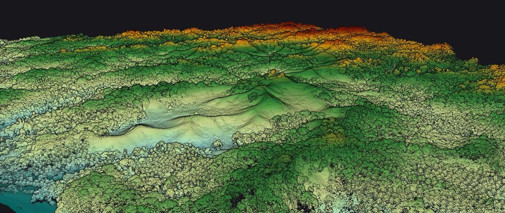
Pointcloud of the forest in Manado area
Parameters
- Survey size: 500 ha (1235 ac) in the Manado area (North Sulawesi)
- Duration: Planned for 2 days but the acquisition was completed in one day and from a single take-off point on top of a hill. The processing (classification and DTM) was carried out by the client.
- Number of flights: 11 flights
- Flight speed and altitude: 6,5m/s (14.5 mph) @ 75m (250 ft) AGL – line spacing 135 metres (440 ft)
- Equipment: YellowScan Vx15-100 with DJI matrix 600 pro. For the photogrammetry Mavic 2 pro
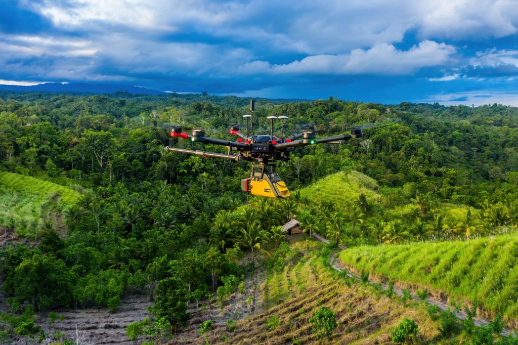
YellowScan Vx15-100 on a DJI M600
Results
The point density was 60 points/m² with an accuracy of 2 cm (0.8 in) after adjustment of the trajectories and stripes. The terrain, previously devastated by deforestation and fire, had little vegetation, which allowed for very good results for DTM generation due to the high point density/m².
MSDI’s client was satisfied with the speed of the acquisition and the results achieved in such a short time. In addition, this assignment probably helped the association to secure new funding from investors and prove the extent of the damage.
There is no doubt that the accuracy of the measurements and the flexibility were key assets for this mission. Indeed, the YellowScan Vx15-100 was easy to set up and the data generation was quick. This LiDAR solution allowed the client to start the reforestation quicker and it saved the MSDI’s team time in the field, reduced their expenses and helped them optimize their time for faster mobilization on other projects.
According to MSDI, there is no secret that quality comes with a price tag and although the cost of acquiring such an instrument is high, the quality and reliability are there. This was demonstrated during their missions in Indonesia, where extreme conditions were overcome thanks to its ability to function in all circumstances. The vegetation penetration, accuracy and small footprint met all their needs. The fact that the laser can acquire 360 degrees means that they were not limited in their services and can respond to any request.
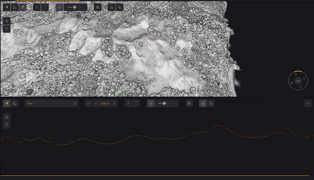
Pointcloud using the the CloudStation’s Vertical Slicing feature
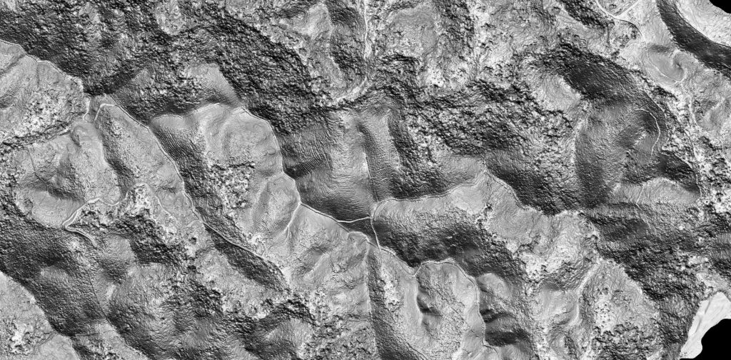
Resulting multidirectional hillshade from the DTM of the
Manado area
Our team is proud to be part of an ecological project to restore biodiversity in Indonesia. Thanks to our LiDAR equipment and the data generated, the engineers were able to optimize the planting of trees and thus quickly recreate all the biodiversity that existed in this area before the fires. We hope that other similar projects will be set up in Indonesia, as this country is an important pillar for the ecological balance of our planet.
Arnaud Denisot
Director – MSDI
We hope that this collaboration can be a great example for other NGOs and organizations that are working with the environment and land-use, to be integrating geomatics into their processes.